TLDR
Réunion Island has exactly one active volcano: Piton de la Fournaise, on the southeastern side of the island. It’s one of the most frequently erupting volcanoes on Earth, averaging roughly one eruption a year, and it erupted again as recently as early 2026, when lava cut the island’s main coastal road for the first time since 2007. The other big peak on Réunion, Piton des Neiges, is dormant, not active. It hasn’t erupted in around 12,000 years.
Table of Contents
- Réunion has one active volcano, not several
- Piton de la Fournaise: the essentials
- Piton des Neiges: the dormant volcano people confuse it with
- A volcano that won’t sit still: eruption history
- Visiting Piton de la Fournaise
- FAQ
Réunion has one active volcano, not several {#one-active-volcano}
Search “active volcanoes in Réunion” and you’ll notice the plural doesn’t hold up. There’s only one: Piton de la Fournaise, French for “Peak of the Furnace.” It sits in the southeastern third of the island, inside a horseshoe-shaped caldera called the Enclos Fouqué, and it’s been building itself up, eruption by eruption, for around 500,000 years.
The confusion usually comes from Réunion’s other giant, Piton des Neiges, which towers over the northern two-thirds of the island at 3,071 meters, making it the tallest peak in the Indian Ocean. It looks the part of an active volcano. It isn’t one. Piton des Neiges went dormant roughly 12,000 years ago and the erosion shows: its slopes have folded into the deep, cirque-shaped valleys of Cilaos, Mafate, and Salazie that Réunion’s hiking reputation is built on. Piton de la Fournaise, by contrast, still has the raw, black, barely-vegetated look of a volcano that erupted last month, because it often has.
Piton de la Fournaise: the essentials {#piton-de-la-fournaise-essentials}
- Elevation: 2,632 meters at the summit crater rim
- Type: Shield volcano, similar in structure to Hawaii’s Kīlauea
- Recorded eruptions: More than 200 since records began, making it one of the three most frequently erupting volcanoes on the planet, alongside Kīlauea and Stromboli
- Average frequency: Roughly once a year, though quiet stretches and busy years both happen
- Caldera: The Enclos Fouqué, about 8 km across, open to the sea on its eastern edge
- Protection status: Part of the Pitons, Cirques and Remparts of Réunion Island UNESCO World Heritage Site, inscribed in 2010
The shield-volcano shape is what makes Piton de la Fournaise relatively low-drama as volcanoes go. Its lava is fluid basalt that flows rather than explodes, which is exactly why it’s erupted more than 200 times without wiping the island off the map. That doesn’t make it harmless. It makes it predictable in a way that Vesuvius or Pinatubo are not, and predictable is a different thing from safe.
Piton des Neiges: the dormant volcano people confuse it with {#piton-des-neiges}
Piton des Neiges built roughly two-thirds of Réunion before it went quiet, and its inactivity is exactly why it’s covered in dense forest and threaded with multi-day trekking routes instead of fresh basalt. Geologists class it as dormant rather than extinct. Twelve thousand years is a short nap on a volcanic timescale, but there’s no monitoring network flagging it the way there is for Fournaise, and nothing in the current seismic record suggests it’s stirring.
The practical distinction for anyone researching the island: if you’re picturing the jagged green cirques and waterfall valleys from Réunion’s tourism photos, that’s Piton des Neiges. If you’re picturing lava fountains, that’s Piton de la Fournaise. They’re two different mountains with two different jobs.
A volcano that won’t sit still: eruption history {#eruption-history}
Piton de la Fournaise has a longer eruption record than most volcanoes get in a lifetime of monitoring. A few points from that record:
- 17th century–present: Written accounts of eruptions go back to the 1600s, and the volcano has erupted well over 200 times since, per the Smithsonian’s Global Volcanism Program.
- 2007: A major eruption drained the summit’s Dolomieu crater floor, which collapsed by more than 300 meters, and sent lava across the coastal road, RN2, cutting the island’s main southern route.
- Late November 2025: Seismic monitors picked up a sharp rise in shallow earthquakes and sulfur dioxide emissions beneath the summit. Authorities raised the alert to “Vigilance” on November 28, the standard warning that an eruption is likely within days or weeks.
- January–April 2026: The forecast played out. An eruption opened on the volcano’s south-southeast flank in mid-January, and by March the lava flow had grown large enough to reach and cut RN2 again, the first time the road had been severed since 2007. The flow continued to the Indian Ocean coastline by mid-March before the eruption wound down in April, and the alert level was stepped back down to Vigilance in May.
That last event is worth sitting with: this isn’t a volcano from a history book. It cut a road on Réunion within the last year, and geologists expect it to do something similar again, because that’s simply what this mountain does.
Visiting Piton de la Fournaise {#visiting}
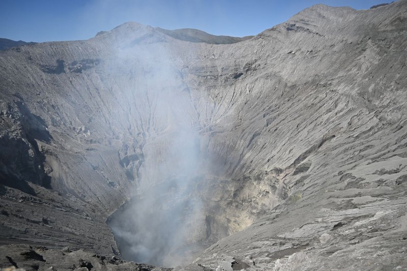
Most visitors reach the volcano through Pas de Bellecombe, a car park and viewpoint at 2,311 meters on the rim of the Enclos Fouqué caldera. From there, a marked trail descends into the caldera and crosses roughly 11 km of hardened lava field to the rim of Dolomieu, the main summit crater, a round trip that takes about five hours for a reasonably fit hiker. There’s no shade and no water source on the trail, so people bring both and start early, before the afternoon clouds roll in and cut visibility to nothing.
Access to the caldera closes without notice whenever seismic activity picks up, which is a good sign the safety system is doing its job rather than an inconvenience. Réunion’s volcanological observatory monitors the mountain continuously, and the alert system, from green to red, is what allowed authorities to call the January 2026 eruption before lava started moving.
For a lower-effort version of the experience, the Cité du Volcan in Bourg-Murat combines a volcanology museum with views toward the mountain, and it’s the better option on days the trail is closed or when hiking 11 km across a lava field isn’t the plan.
FAQ {#faq}
Is Piton de la Fournaise dangerous? To residents and hikers who respect the alert system, rarely. Its lava is slow-moving basalt, not the explosive kind, and Réunion’s observatory tracks seismic activity closely enough to warn of eruptions days or weeks ahead, as it did in November 2025. The risk is mostly to property and roads in the lava’s path, not sudden loss of life, though gas emissions and unstable crater rims are real hazards for anyone who ignores closures.
Can you actually see lava? Sometimes, and only during an active eruption, which happens roughly once a year but on no fixed schedule. When Fournaise is erupting, authorities often open designated viewpoints so people can watch from a safe distance. Outside of an eruption, you’re hiking across the black, solidified evidence of the last one rather than watching a new one form.
What’s the best time to visit? For the hike itself, Réunion’s dry season, from May to November, gives the clearest weather and the best odds the trail is open. If seeing an active eruption is the goal, there’s no way to time that in advance. Following the observatory’s public alert updates in the weeks before a trip is the closest thing to a heads-up.
Are there other volcanoes on Réunion I should know about? No others that qualify as active. Piton des Neiges is dormant, and the volcanic history that built the rest of the island happened long before written records. For practical purposes, “the volcano” on Réunion means one mountain.