Table of Contents
- The Four Zones, at a Glance
- The Splash (Spray) Zone
- The High Intertidal Zone
- The Middle Intertidal Zone
- The Low Intertidal Zone
- How to Tell Which Zone You’re Standing In
- Why the Bands Are So Sharp
- Where to See It for Yourself
Stand on a rocky shore at low tide and you’re not looking at one habitat. You’re looking at four, stacked on top of each other like a layer cake, each one governed by a different math problem: how many hours a day does this exact spot spend underwater. That single number decides who can live there, and it changes so fast over just a few vertical feet that you can watch the animal life switch from mostly barnacles to mostly sea stars in the space of a few steps.
Marine ecologists split this vertical strip into four tidal zone classifications — splash (or spray), high, middle, and low intertidal — based on tidal exposure rather than distance from the water. It’s a system built on physiology as much as geography: NOAA’s ocean service notes that the intertidal is one of the most physically demanding habitats on Earth precisely because its residents have to tolerate both open air and open ocean, sometimes within the same hour.
The Four Zones, at a Glance
| Zone | Underwater | Key stress | Indicator species |
|---|---|---|---|
| Splash / spray | Almost never — sea spray and rain only | Desiccation, extreme temperature swings | Periwinkles, rock lice, black lichen-like cyanobacteria |
| High intertidal | Only at daily high tide | Long dry stretches, direct sun | Acorn barnacles, dog whelks, small blue mussels |
| Middle intertidal | Twice daily, tide in and out | Wave shock, moderate drying | Rockweed, California mussels, aggregating anemones, limpets |
| Low intertidal | Nearly always, exposed only at spring low tide | Predation, competition for space | Sea stars, sea urchins, sea hares, nudibranchs |
That table is the map. Everything below is why the borders fall exactly where they do.
The Splash (Spray) Zone

Technically this strip sits above the tide line entirely — the supralittoral, if you want the textbook term. It floods only during storm surges and the highest tides of the month; the rest of the time it survives on salt spray kicked up by breaking waves and whatever rain happens to fall. That’s a rough deal for anything that breathes through gills.
What manages it are organisms built for air more than water. Periwinkle snails work their way into the lower fringe of this zone, sealing themselves into their shells to ride out dry spells that would kill a fish in minutes. The dark, almost sooty band of rock you’ll notice at the very top of a seawall or cliff face isn’t dirt — it’s a colony of blue-green cyanobacteria (Calothrix), tough enough to survive weeks without a proper soaking. Rock lice and a handful of barnacles round out the short guest list. Diversity here is intentionally thin; this is the zone natural selection charges the highest rent for.
The High Intertidal Zone
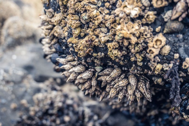
Move down a few feet and you hit ground that floods once or twice a day, during the peak of high tide, then sits dry for the many hours in between — often eight to ten hours of exposure between dunkings. That’s still long enough that anything living here needs a real strategy against drying out, not just a shell to hide in.
Acorn barnacles dominate the visual texture of this band, cemented head-down in white, gritty crusts that can cover a boulder almost completely. Small blue mussels wedge into cracks in loose clusters, and dog whelks patrol between them, drilling into barnacle shells with a radula — a tongue lined in tiny teeth — to feed. A thin film of algae coats the rock in wet weather and crisps to nothing when the sun’s been out. It’s a harsher stretch than it looks from a distance; every organism here is doing the intertidal equivalent of holding its breath for most of the day.
The Middle Intertidal Zone
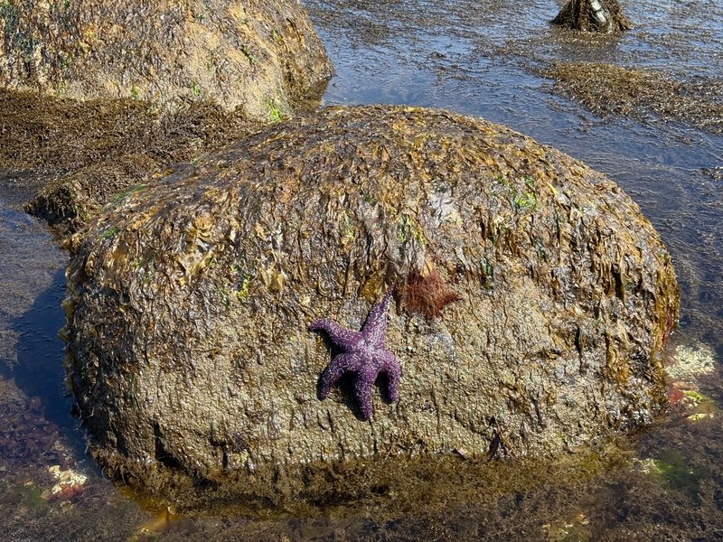
This is the zone most people mean when they picture a tide pool. It floods and drains with the regular rhythm of the tide, twice a day, and that predictability supports far more life than the harsher bands above it. National Geographic Education points to the middle intertidal as the zone where species diversity climbs sharply compared to the high zone, and on a rocky shore it’s obvious why: enough submersion time to feed like a marine animal, enough air exposure to still count as intertidal.
Rockweed and other brown algae carpet the rock, giving the whole band its characteristic slick, olive-green look and doubling as cover for whatever’s hiding underneath. California mussels form dense beds anchored by tough protein threads. Aggregating anemones close into dull maroon blobs when the water drops and unfurl into full bloom the moment it returns. Limpets and chitons graze algae off bare rock in slow, deliberate loops, and hermit crabs work the tide pools left behind between the larger rocks. If you’re going to spend twenty minutes crouched over one square meter of shoreline, this is the band that rewards it.
The Low Intertidal Zone
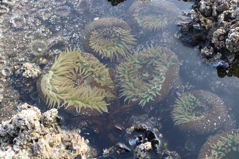
The bottom band spends most of its life underwater, exposed only during the lowest tides of the lunar cycle — the spring tides that happen around new and full moons. Because it’s rarely dry, this zone looks and behaves almost like a shallow reef, and it’s where intertidal life gets genuinely colorful.
Sea stars, sea urchins, and California sea hares show up here in numbers you won’t find higher on the shore, alongside nudibranchs, sponges, and the occasional octopus tucked into a crevice. Goose barnacles and California mussels form dense, tangled assemblages low on the rocks, and predator-prey relationships get more intense — sea stars here are a genuine ecological force, capable of controlling mussel populations across an entire stretch of coast. Catching this zone exposed is a matter of timing your visit to a real spring low, not just “low tide” in general.
How to Tell Which Zone You’re Standing In
Tide charts tell you what the water’s doing right now. Indicator species tell you what it does every day, which turns out to be more useful when you’re already out on the rocks. Look down before you look at your phone:
- Black, crusty patches with almost no other life → splash zone. You’re above the reach of most tides.
- A solid white crust of barnacles, maybe with scattered mussels → high intertidal.
- Olive-brown seaweed cover with mussels, anemones, and limpets mixed in → middle intertidal.
- Sea stars, urchins, or nudibranchs, and the rock still feels wet even in “dry” patches → low intertidal, and you’re on borrowed time before the tide turns.
This is a faster read than trying to estimate vertical height above the waterline, and it works on shores you’ve never visited before, since the same zonation pattern — driven by exposure time, not geography — repeats on rocky coastlines worldwide.
Why the Bands Are So Sharp
The transitions between zones aren’t gradual gradients — they’re closer to lines, and that surprises people the first time they see it. A few vertical inches of rock can separate “covered in barnacles” from “almost bare.” The Coastal Wiki attributes this to how nonlinearly tidal exposure time changes with elevation on the shore: a small rise in height translates into a disproportionately large jump in hours spent dry, because of how tide curves are shaped. Competition does the rest — species that could technically survive one zone up often get outcompeted for space and food by residents better adapted to the wetter conditions, so they get pushed into the driest band they can physically tolerate rather than the one they’d prefer.
Where to See It for Yourself
Rocky shore zonation shows up wherever hard rock meets a tidal coastline, but a few spots make it unusually easy to read. Point Reyes National Seashore and the Olympic National Park coast both have accessible rocky benches with textbook zonation bands. Acadia National Park’s rocky shoreline in Maine shows the same pattern on the Atlantic side, with rockweed standing in for some of the Pacific species. Wherever you go, check a tide chart for a low or minus tide, wear shoes you don’t mind getting wet, and step carefully — the middle and low zones are alive with things that would rather not be stepped on.
None of this requires equipment beyond curiosity and decent timing. The tide does the same thing every single day; it’s just a matter of showing up when it’s out.