Iceland sits on a geological seam that almost no other inhabited country can claim. The Mid-Atlantic Ridge — the crack where the North American and Eurasian plates pull apart — runs straight through the island, and a deep mantle plume sits underneath it. That combination is rare. Most volcanic countries get one or the other. Iceland gets both, stacked on top of each other, which is why a chunk of rock the size of Kentucky carries roughly 130 volcanic systems, around 30 of them still capable of erupting.
The country erupts, on average, every three to four years. Since 2021 that pace has gone into overdrive on the Reykjanes Peninsula, the spit of land where Keflavík airport sits. If you’ve flown into Iceland recently, you landed minutes from the most active stretch of ground in Europe.
This guide covers the volcanoes that actually matter right now: where they are, when they last went off, what status they’re in, and the honest answer to the question most travelers are really asking — can I see one, and is it safe.
Table of Contents
- Quick Reference Table
- Can I Visit a Volcano Right Now?
- Sundhnúkagígar (the Grindavík eruptions)
- Fagradalsfjall
- Katla
- Hekla
- Grímsvötn
- Bárðarbunga
- Eyjafjallajökull
- How to See a Volcano Without a Tour
- FAQ
Quick Reference Table {#quick-reference-table}
| Volcano | Region | Last Eruption | Status | Easy to See? |
|---|---|---|---|---|
| Sundhnúkagígar | Reykjanes (SW) | 2024–2025 | Highly active | Sometimes (depends on activity & closures) |
| Fagradalsfjall | Reykjanes (SW) | 2023 | Active system, dormant phase | Yes, when erupting |
| Katla | South | 1918 | Restless, overdue | Crater under ice — no |
| Hekla | South | 2000 | Active, quiet | Hikeable when calm |
| Grímsvötn | Vatnajökull (SE) | 2011 | Active | Under ice cap — no |
| Bárðarbunga | Vatnajökull interior | 2014–2015 | Active | Remote — no |
| Eyjafjallajökull | South | 2010 | Dormant | Viewable, not erupting |
Can I Visit a Volcano Right Now? {#can-i-visit-a-volcano-right-now}
Here’s the bottom line before the details: most of the time, no eruption is visibly happening, and that’s the normal state of Iceland. When something is erupting, access depends entirely on where it is and what the authorities decide that week.
Two rules will keep you out of trouble. First, check the official Icelandic Met Office and the police-run SafeTravel.is site before you go anywhere near an active zone — they post closures, gas warnings, and hazard maps in English, and those pages are the difference between a great hike and a serious mistake. Second, never approach an active vent on your own judgment. Volcanic gas (sulfur dioxide and carbon dioxide) pools in low ground with no smell strong enough to warn you, and fresh lava crust can collapse under your weight.
The eruptions on Reykjanes since 2021 have been “tourist-friendly” only by accident — effusive lava flows rather than explosive ash blasts. The distinction matters more than it sounds: the two behave like completely different types of volcanoes, and which one you’re standing near decides whether you get a glowing river of rock or a grounded airport. That can change fast. When the Icelandic Met Office raises an aviation color code or the police close a road, the answer is no, regardless of what a tour operator’s website still says.
Sundhnúkagígar (the Grindavík eruptions) {#sundhnukagigar}
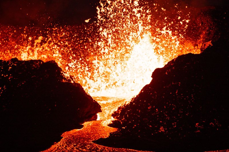
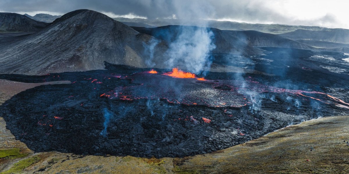
This is the one in the news. The Sundhnúkur crater row, just north of the fishing town of Grindavík, has produced a remarkable cluster of eruptions — repeated fissure openings from December 2023 through 2024 and into 2025, the most frequent series on the peninsula in roughly 800 years. The November 2023 magma intrusion cracked Grindavík itself, forcing the town’s evacuation and damaging homes and roads.
What makes Sundhnúkagígar different from the earlier Fagradalsfjall shows is proximity to infrastructure. The lava has threatened the Blue Lagoon, the Svartsengi geothermal power plant, and the town. Authorities built defensive barriers — earthen walls to redirect flows — which mostly held but didn’t always.
For visitors, the practical reality is that this area is frequently closed. When eruptions occur here, viewing is tightly controlled and often forbidden because of the danger to the power plant and town. Don’t plan a trip around seeing it; treat it as a bonus if conditions and the authorities allow.
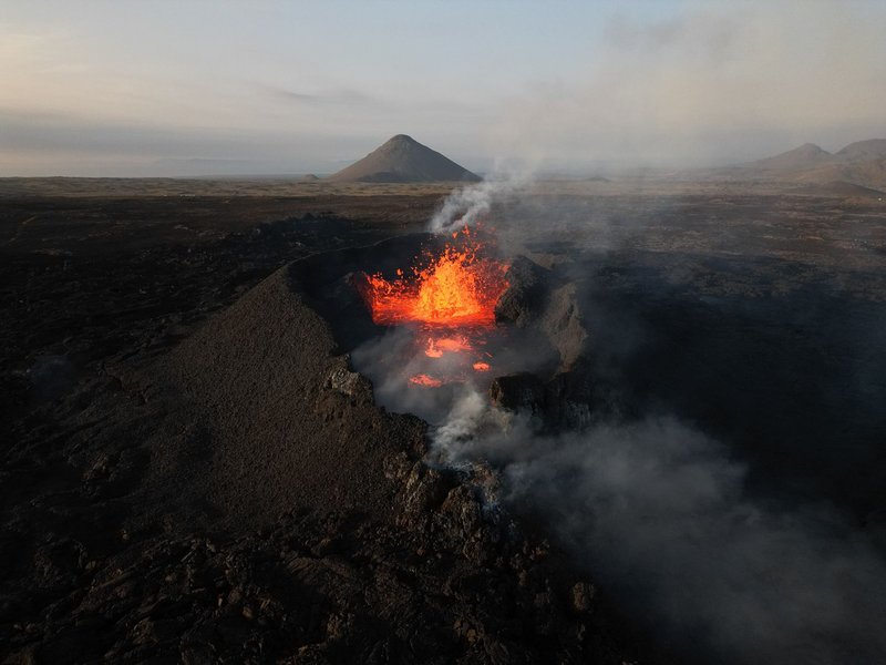
Fagradalsfjall {#fagradalsfjall}
Fagradalsfjall is the volcano that made Iceland a viral hiking destination. Its 2021 eruption in the Geldingadalir valleys lasted about six months, opened gently in an uninhabited valley a manageable hike from the car park, and gave hundreds of thousands of people their first chance to stand near flowing lava without a helicopter. Shorter follow-up eruptions came in 2022 and 2023.
The system had been dormant for roughly 6,000 years before 2021, which tells you something: Reykjanes runs in cycles of centuries-long quiet followed by decades of activity, and we’ve clearly entered an active phase. When Fagradalsfjall is erupting and the site is open, it’s the most accessible lava-watching in Iceland — a marked trail, no glacier, no boat. When it’s not erupting, the hardened lava fields are still worth the walk, though far less dramatic.
Katla {#katla}
Katla is the one geologists keep half an eye on. It sits beneath the Mýrdalsjökull ice cap on the south coast, and it’s both powerful and overdue. Historically it erupts every 40 to 80 years; the last major eruption was 1918, which makes the current gap unusually long. Because the crater sits under hundreds of meters of ice, a Katla eruption typically triggers a jökulhlaup — a glacial flood — alongside heavy ash.
You can’t see Katla’s crater; it’s buried. But you can stand on the system. The famous ice caves and glacier hikes on Mýrdalsjökull, and the popular Katla ice cave tours near Vík, run right on top of it. The volcano’s restlessness is monitored constantly, and any sharp uptick in earthquakes under Mýrdalsjökull makes international news.
Hekla {#hekla}
For most of recorded Icelandic history, Hekla was “the Gateway to Hell” — medieval Europeans believed the souls of the damned were dragged into its crater. It’s one of the country’s most active volcanoes, with major eruptions in 1947, 1970, 1980, 1991, and most recently 2000.
Hekla’s reputation among scientists is for short warning times. Some of its eruptions have given only an hour or two of detectable precursors, which is why it’s never a casual hike during periods of unrest. When it’s quiet, experienced hikers do summit it. The mountain’s long ridge shape — it’s been compared to an overturned boat — is visible from much of the south, and on a clear day you can pick it out from the Ring Road.
Grímsvötn {#grimsvotn}
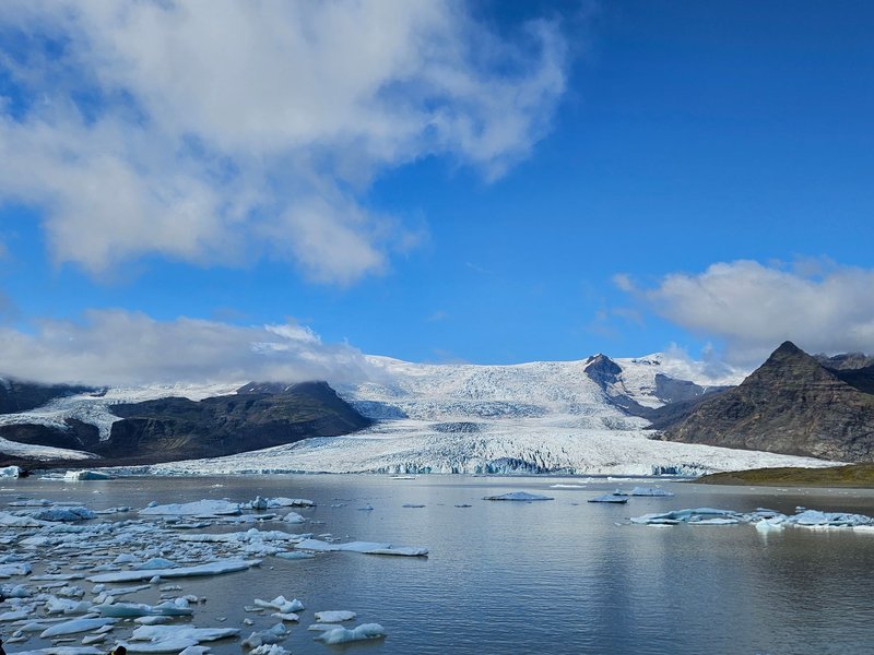
Grímsvötn is Iceland’s most frequently erupting volcano, and almost nobody ever sees it. It lies under the vast Vatnajökull ice cap, Europe’s largest glacier outside the Arctic islands. Its 2011 eruption threw an ash plume some 20 kilometers high and briefly disrupted European air travel, though far less than its smaller neighbor did the year before.
Because it sits under ice, Grímsvötn’s eruptions are explosive (magma meeting meltwater) and often paired with glacial floods. The subglacial caldera is a destination only for research expeditions, not tourists. Its main relevance to a traveler is the same as Katla’s: it’s a reminder that Iceland’s most active volcanoes are the ones you’ll never lay eyes on.
Bárðarbunga {#bardarbunga}
Bárðarbunga sits deep in the interior under Vatnajökull and produced one of the largest eruptions of the 21st century. The 2014–2015 Holuhraun eruption wasn’t at the volcano itself — magma traveled underground for about 45 kilometers and surfaced in a remote lava field north of the glacier, eventually covering an area larger than Manhattan. It erupted for six months and pumped out staggering volumes of sulfur dioxide.
Holuhraun happened in one of the most inaccessible parts of the country, far from any road, which is exactly why most people only know it from photographs. Bárðarbunga remains an active, closely watched system, but it’s not a place a visitor will stumble across.
Eyjafjallajökull {#eyjafjallajokull}
The volcano nobody could pronounce. Eyjafjallajökull’s 2010 eruption was modest by Icelandic standards, but it erupted under ice in just the wrong wind conditions, sending fine ash across European airspace and grounding more than 100,000 flights — the largest air-travel shutdown since World War II, affecting roughly 10 million passengers, according to reporting at the time.
It’s been dormant since. You can drive right up to its base on the south coast; the visitor center at Þorvaldseyri farm tells the story from the perspective of the family that lived through the ashfall. The waterfalls Seljalandsfoss and Skógafoss both sit on this volcano’s flanks, so most south-coast travelers see Eyjafjallajökull without realizing it.
How to See a Volcano Without a Tour {#how-to-see-a-volcano-without-a-tour}
You don’t need a guided package to get close to Iceland’s volcanic landscape — only to get close to active lava safely, and even then mostly just when access is open.
If you’re self-driving on a budget, the south coast Ring Road delivers the most volcano per krona. You’ll pass Eyjafjallajökull, skirt Katla’s ice cap above Vík, and see Hekla inland on a clear day, all without leaving the highway. The Reykjanes Peninsula, a 40-minute drive from Reykjavík, is one continuous volcanic field — moss-covered lava, steaming vents, and (when open) the Fagradalsfjall trail to recent flows. It’s worth knowing what you’re looking at out there; not every dramatic landform is a textbook cone, and some countries that “have no volcanoes” still carry mud vents and extinct peaks that look the part, which makes Iceland’s living systems all the more striking by comparison.
What you do need a guide for: ice caves on Vatnajökull or Mýrdalsjökull, any glacier hike, and any approach to an active eruption. Glacier travel without equipment and training kills people most years, and active eruption sites are gated for a reason. For everything else — craters, lava fields, the geothermal areas at Krýsuvík and Námafjall — a rental car and the SafeTravel.is map are all you need. Check road and closure status the morning you go, not the week before; Iceland changes its mind about access faster than guidebooks can keep up.
FAQ {#faq}
How many active volcanoes does Iceland have? Around 30 active volcanic systems out of roughly 130 total, spread along the rift that crosses the country from the southwest to the northeast.
Is it safe to travel to Iceland right now with the eruptions? For the vast majority of the country, yes. The recent Reykjanes eruptions are localized near Grindavík and the Blue Lagoon; Reykjavík, the airport, and the main tourist routes have stayed open and safe. Always confirm current conditions on SafeTravel.is before visiting any active zone.
Which Iceland volcano is most likely to erupt next? The Reykjanes Peninsula (the Sundhnúkagígar/Svartsengi system) is the hot spot, having erupted repeatedly since 2021. Among the big classic volcanoes, Katla is considered overdue, last erupting in 1918.
Can I see lava in Iceland? Only during an active eruption, and only when authorities open the site. There’s no permanent lava lake to visit. When nothing is erupting, you can still walk on vast hardened lava fields, especially on Reykjanes.
Did the 2010 eruption really shut down European air travel? Yes. Eyjafjallajökull’s ash cloud grounded over 100,000 flights and stranded around 10 million travelers over several days, the biggest peacetime disruption to European aviation on record.