Ice shapes coastlines, feeds rivers, and preserves a layered record of past climates—from the vast Antarctic ice sheet to nimble mountain glaciers. Scientists map, measure, and model ice to predict sea-level rise, manage freshwater, and understand how Earth’s climate has changed.
There are 15 Branches of Glaciology, ranging from Cryospheric remote sensing to Subglacial processes. Each branch covers different scales and techniques, from satellites and radar to field drilling and modeling. For clarity and comparison, the list below organizes information with Focus,Key methods,Representative example/location so you can quickly see what each branch studies and where it’s applied; you’ll find below.
Which branch should I explore if I want to learn about past climates from ice?
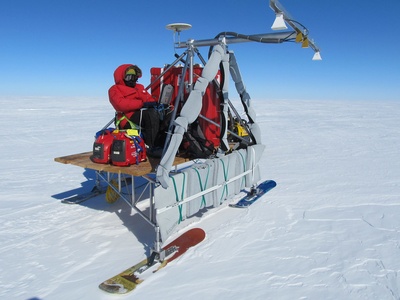
Ice-core paleoclimatology (part of glaciochemistry and paleoglaciology) is the go-to area: it combines field drilling, isotopic and chemical analyses, and age modeling to read climate signals trapped in layers—common study sites are Greenland and Antarctic ice cores.
How do researchers investigate processes happening beneath a glacier?
Subglacial studies use boreholes, ground-penetrating radar, seismic surveys, hot-water drilling, and numerical models to probe ice-bed interactions and subglacial hydrology; sampling bed sediments and water plus in situ sensors reveal how the hidden base controls ice flow and stability.
Branches of Glaciology
| Name | Focus | Key methods | Representative example/location |
|---|---|---|---|
| Physical glaciology | Ice deformation and flow mechanics | Field measurements,GPS,ice-penetrating radar,laboratory rheology | Jakobshavn Isbræ, Greenland |
| Ice-sheet dynamics | Large ice sheet flow and stability | Satellite altimetry,ice-penetrating radar,numerical models | West Antarctic Ice Sheet |
| Glacier hydrology | Water flow within and beneath glaciers | Dye tracing,discharge measurements,boreholes,hydrochemistry | Rhone Glacier, Switzerland |
| Subglacial processes | Basal sliding,meltwater and bed interactions | Borehole sensors,seismic surveys,ROVs,radar | Siple Coast, Antarctica |
| Glacial geomorphology | Landforms created and modified by ice | Field mapping,LiDAR,sediment analysis,cosmogenic dating | Patagonia icefields; Scottish Highlands |
| Paleoglaciology | Reconstructing past glaciers and ice sheets | Cosmogenic dating,sediment cores,ice cores,modeling | Laurentide Ice Sheet reconstructions |
| Ice-core science | Climate and atmospheric records in ice cores | Ice coring,isotope analysis,gas trapping,chronology | Greenland GISP2; EPICA Dome C, Antarctica |
| Glacier mass balance | Measuring gains and losses of glacier mass | Stake networks,remote sensing,gravimetry,modeling | Swiss Alps long-term glaciers |
| Cryospheric remote sensing | Observing ice from space and aircraft | Satellites,LiDAR,SAR,optical imagery,altimetry | Greenland and Antarctic ice sheets |
| Sea-ice science | Formation, dynamics and thermodynamics of sea ice | Ice buoys,radar,ship observations,numerical models | Arctic Ocean, Beaufort Sea |
| Glacier microbiology | Microbial life in snow, ice and cryoconite | DNA sequencing,culturing,microscopy,biogeochemical assays | Cryoconite holes, Greenland Ice Sheet |
| Glacial geochemistry | Chemical composition and reactions in ice and meltwater | Ion chromatography,isotope ratios,mass spectrometry | Antarctic coastal glaciers |
| Glacial seismology | Seismic signals from ice motion and fracturing | Seismometers,acoustic sensors,geophone arrays | Icequakes at Jakobshavn Isbræ |
| Glacier hazard and risk management | Predicting and mitigating ice-related hazards | Remote sensing,field monitoring,models,early-warning systems | Tsho Rolpa glacial lake, Nepal |
| Firn and snowpack processes | Compaction,melt percolation and firn-air interactions | Snow pits,cores,density profiling,stable isotopes | Greenland firn zones |
Images and Descriptions
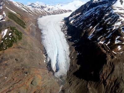
Physical glaciology
Physical glaciology studies how glacier ice deforms and flows at scales from crystals to entire glaciers. It combines lab rheology, field observations and theory to explain sliding, internal deformation, surges and flow variations that shape landscapes and control ice loss.
Ice-sheet dynamics
Ice-sheet dynamics focuses on how continental-scale ice masses flow and respond to climate and ocean forcing. Researchers use observations and models to assess ice-shelf collapse, grounding-line migration and potential rapid ice loss that influences global sea level over decades to millennia.
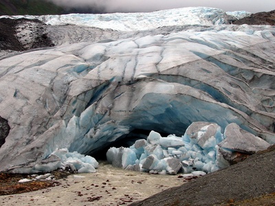
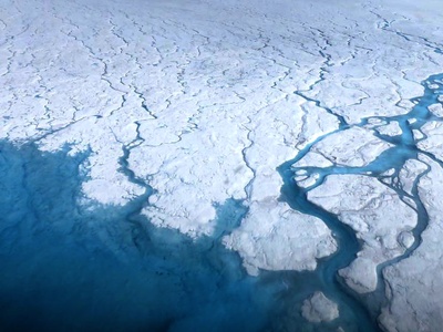
Glacier hydrology
Glacier hydrology examines meltwater generation, routing through crevasses and tunnels, and how water affects motion and erosion. Understanding drainage systems explains seasonal speed-ups, subglacial sediment transport and downstream flood hazards during warming climates.

Subglacial processes
Subglacial processes study the interface between ice and bedrock or sediment, including basal sliding, melting, and subglacial lakes. This work reveals how lubrication and bed properties control glacier speed and stability, with implications for ice-sheet collapse and sea-level rise.
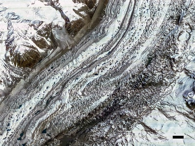
Glacial geomorphology
Glacial geomorphology documents the scars glaciers leave: moraines, drumlins and U-shaped valleys. By mapping landforms and sediments, scientists reconstruct past ice extent, erosion rates and landscape evolution, connecting glaciers to long-term Earth surface change.
Paleoglaciology
Paleoglaciology reconstructs former ice extents, thicknesses and timing during ice ages using landforms, sediments, ice cores and models. It helps reveal how ice sheets responded to past climates and guides predictions of future ice behavior under warming.
Ice-core science
Ice-core science extracts layered climate archives from ice sheets to read past temperature, greenhouse gases and volcanic events. High-resolution chemistry and gas records let scientists trace climate variability, atmospheric composition and abrupt events over hundreds to hundreds of thousands of years.
Glacier mass balance
Mass-balance studies quantify how much ice glaciers gain from snow or lose through melt and calving. Combining field stakes, satellite surveys and gravimetry yields essential data for sea-level projections and water-resource planning in glacier-fed regions.
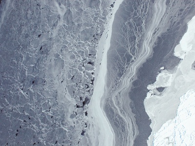
Cryospheric remote sensing
Remote sensing provides large-scale and frequent views of glaciers and sea ice using satellites and airborne sensors. It measures changes in area, elevation, velocity and ice-surface properties, enabling monitoring of remote regions and feeding models of ice change.
Sea-ice science
Sea-ice science studies the seasonal growth, drift, deformation and melting of ocean ice and its exchange with atmosphere and ocean. This field is central to polar ecosystems, navigation, climate feedbacks and understanding changing Arctic and Antarctic sea-ice cover.
Glacier microbiology
Glacier microbiology explores the tiny ecosystems that live on and within ice, from bacteria in cryoconite holes to fungi in snow. Microbes alter albedo, drive nutrient cycles and record environmental change, linking biology to glacier melt and chemistry.
Glacial geochemistry
Glacial geochemistry tracks chemical signals in ice and melt to understand pollution transport, weathering, nutrient release and past atmospheric composition. It helps parse sources of meltwater solutes and interpret ice-core chemical records relevant to climate studies.
Glacial seismology
Glacial seismology records creaks, calving events and basal quakes to infer ice dynamics and fracture processes. Seismic studies reveal glacier stick-slip behavior, calving mechanics and subglacial water flow, offering high-time-resolution views of glacier activity.
Glacier hazard and risk management
This applied subfield assesses hazards like glacial lake outburst floods, avalanches and ice-dammed lakes. Combining observations, modeling and engineering, practitioners design mitigation, evacuation planning and infrastructure protection for communities downstream of glaciers.
Firn and snowpack processes
Firn science studies the porous transitional layer between snow and glacial ice, focusing on densification, meltwater percolation and air storage. Firn affects ice-sheet mass balance, sea-level estimates and interpretation of satellite altimetry and ice-core gas records.