Every thunderstorm runs on the same engine: warm, moist air rises, cools, condenses, and dumps its energy back out as rain, wind, and lightning. But the way that energy gets organized changes everything. A storm that fizzles in 20 minutes and a storm that spawns an EF5 tornado are built from the same raw ingredients — they just assemble differently.
Meteorologists sort thunderstorms into a handful of categories based on how their updrafts and downdrafts are arranged. Get that organization right and you can predict, roughly, whether a storm will give you a pleasant evening light show or send you to the basement.
Here are the five types you’ll actually encounter, each with a real-world example, the specs that matter, and how to tell them apart.
Table of Contents
- First, the engine: how a thunderstorm lives and dies
- 1. Single-cell (ordinary) thunderstorms
- 2. Pulse storms
- 3. Multi-cell cluster storms
- 4. Squall lines
- 5. Supercells
- Comparison table: all five types at a glance
- How thunderstorms form: the three triggers
- FAQ
- Staying safe
First, the engine: how a thunderstorm lives and dies
Before the types make sense, you need the life cycle. Every ordinary thunderstorm cell goes through three stages, and the whole arc usually takes 30 to 60 minutes.
Developing (cumulus) stage. A column of warm air rises and builds a towering cumulus cloud. The air inside is almost entirely updraft — moving up at speeds that can exceed 50 mph in a strong storm. No rain reaches the ground yet because the rising air holds the water droplets aloft.
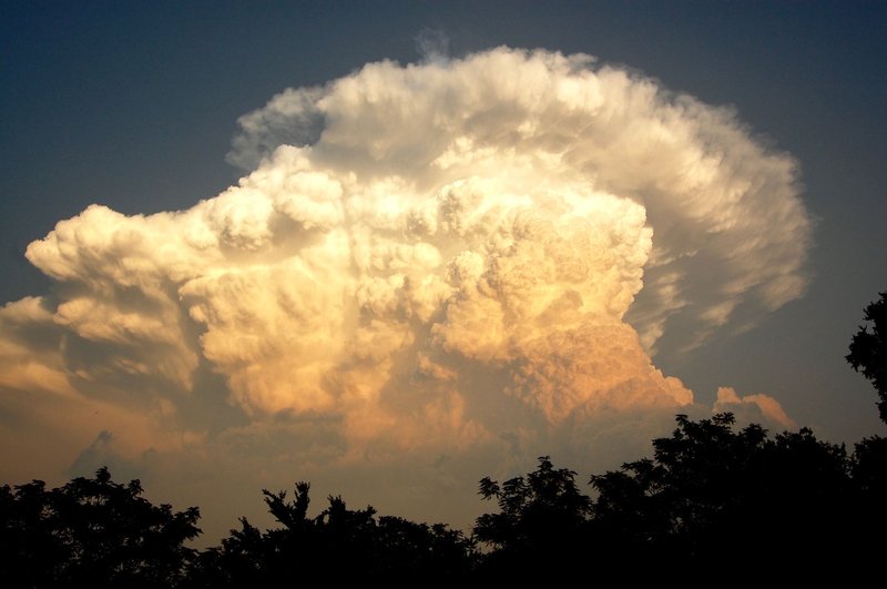
Mature stage. This is the dangerous part. The cloud has grown tall enough that water droplets and ice grow too heavy to stay suspended, and they fall — dragging cold air down with them. Now you have an updraft and a downdraft side by side. Rain, hail, lightning, and the strongest winds all happen here. The cloud often flattens into the classic anvil shape at the top, where it hits the stratosphere and can’t rise any further.
Dissipating stage. The downdraft wins. Cold, sinking air cuts off the warm updraft that fed the storm, and without fuel the cell collapses. Rain tapers to a drizzle. The whole thing is over.
That self-destruct mechanism — the downdraft choking off its own updraft — is the key to understanding storm types. The categories below are essentially different answers to one question: how does the storm keep its updraft alive?
1. Single-cell (ordinary) thunderstorms
A single-cell storm is one cell running through that life cycle once and then dying. No tricks, no organization. These are the “garden variety” storms you get on a humid summer afternoon when the atmosphere is unstable but there’s little wind shear to organize anything bigger.
Because the downdraft kills the updraft, single-cell storms are short — 20 to 30 minutes of real activity. They’re mostly local and rarely severe, though a strong one can briefly produce small hail or a quick gust of damaging wind.
A real example: the afternoon pop-up storms that roll across Florida nearly every summer day. The Florida peninsula is the single-cell capital of the United States — sea breezes from both coasts collide inland, force air upward, and brick by brick build isolated towers that bloom around 2 p.m. and are gone by dinner. Central Florida sees thunder on more than 80 days a year, most of it from exactly this kind of storm.
Quick specs: Duration ~30 min | Wind/hail threat: low | Forms in warm, moist, low-shear air
2. Pulse storms
A pulse storm is a single-cell storm with a bad attitude. Same structure — one cell, short life — but it forms in an atmosphere with more instability, so its updraft surges hard enough to briefly turn severe. The “pulse” is that sudden burst of strength.
The problem with pulse storms is timing. They can spike from harmless to dangerous in 15 minutes, dropping a downburst (a violent, localized rush of sinking air) or large hail with almost no warning, then collapse before forecasters can issue much of an advisory. Their unpredictability is exactly what makes them tricky.
A real example: the scattered “air-mass” storms across the Southeast and Gulf Coast on muggy July afternoons. One cell over a single county might produce a 60 mph wind gust that snaps tree limbs and knocks out power for a neighborhood, while the next town over stays dry. NOAA’s JetStream classifies these as ordinary cells that happen to briefly cross the severe threshold.
Quick specs: Duration ~30 min | Wind/hail threat: brief but severe | Forms in high-instability, low-shear air
3. Multi-cell cluster storms
Now the storms learn to cooperate. A multi-cell cluster is a group of cells in different life-cycle stages, moving and feeding off each other as a single system. This is the most common type of thunderstorm.
Here’s the clever part. When a mature cell’s downdraft hits the ground, it spreads out as a wall of cool air called a gust front. That gust front acts like a tiny cold front, shoving warm air ahead of it upward — which triggers a brand-new cell. So as the old cell dies, a fresh one is already being born on the storm’s leading edge. The cluster keeps regenerating and can last for hours, even though each individual cell still lives and dies in 30 minutes.
Because new cells keep firing, multi-cell clusters can hammer the same area with repeated rounds of heavy rain, hail, and gusty wind. Flash flooding becomes a real risk when cell after cell tracks over the same ground — a phenomenon called “training,” like railcars passing one spot on the track.
A real example: the slow-moving clusters that stalled over Ellicott City, Maryland, in 2016 and again in 2018, dumping six-plus inches of rain in a few hours and sending a flash flood roaring down Main Street both times.
Quick specs: Duration: hours | Wind/hail/flood threat: moderate to high | Forms with moderate shear
4. Squall lines
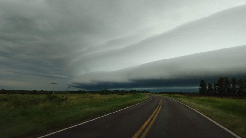
Take that multi-cell organization and stretch it into a line, and you get a squall line — a continuous wall of thunderstorms that can run for hundreds of miles, often along or ahead of a cold front. If you’ve ever watched a solid bar of red and purple sweep across the radar, that’s a squall line.
The signature threat is straight-line wind. The combined downdrafts of all those cells pool into one massive gust front, frequently marked by a dramatic, low, arc-shaped shelf cloud at the leading edge. When the winds get strong enough and the line bows outward on radar, it earns the name “bow echo.”
The most extreme squall lines produce a derecho — a single, fast-moving windstorm that travels at least 240 miles and packs gusts of 58 mph or higher along its path. A derecho is essentially a hurricane’s worth of wind delivered in a straight line over land.
A real example: the June 2012 derecho that exploded across the Midwest and Mid-Atlantic. It started near Chicago, traveled roughly 700 miles to the Atlantic coast in about 12 hours, produced wind gusts over 80 mph, killed at least 22 people, and left around four million customers without power during a brutal heat wave. The National Weather Service still uses it as a textbook case.
Quick specs: Length: 100s of miles | Wind threat: high (straight-line) | Forms along cold fronts in high shear
5. Supercells
The supercell is the apex predator. It’s rare — only a small fraction of thunderstorms qualify — and it’s defined by one feature no other storm has: a rotating updraft called a mesocyclone.
That rotation is the whole game. In every other storm type, the downdraft eventually undercuts the updraft and kills it. A supercell solves the self-destruct problem by tilting and spinning, which physically separates the updraft from the downdraft so the rain falls away from the rising air instead of choking it. The result is a single, organized, rotating storm that can sustain itself for hours and grow monstrously tall and powerful.
Because the updraft is so strong and persistent, supercells produce the worst of everything: the largest hail (sometimes bigger than baseballs), the most violent straight-line winds, and the overwhelming majority of strong-to-violent tornadoes. The rotating mesocyclone is the parent structure from which a tornado descends.
A real example: the supercell that produced the El Reno, Oklahoma, tornado on May 31, 2013. At one point its damage path stretched 2.6 miles wide — the widest tornado ever recorded — and radar clocked winds near 300 mph inside it. It also killed three veteran storm chasers, a sobering reminder that these storms don’t follow the script even experts expect.
Quick specs: Duration: hours | Hail/wind/tornado threat: extreme | Forms in high-instability, high-shear environments
Comparison table: all five types at a glance
| Type | Structure | Typical duration | Main threats | Where/when |
|---|---|---|---|---|
| Single-cell | One cell, one life cycle | ~30 min | Minor; brief small hail/gusts | Warm, low-shear afternoons (e.g. Florida) |
| Pulse | One strong cell | ~30 min | Brief downburst, large hail | High instability, low shear |
| Multi-cell cluster | Group of cells regenerating | Several hours | Hail, flooding, gusty wind | Moderate shear; most common type |
| Squall line | Cells in a long line | Hours | Straight-line wind, derechos | Along cold fronts, high shear |
| Supercell | Single rotating updraft | Hours | Giant hail, violent wind, tornadoes | High instability + high shear |
How thunderstorms form: the three triggers
Every storm above needs the same three ingredients — moisture, instability (warm air that wants to rise), and a lift mechanism to get it started. That third one, the lift, comes in three flavors, and it explains why storms pop up where they do.
Air-mass (convective) lift. The sun heats the ground, the ground heats the air, and that warm air rises on its own. This is what builds those Florida afternoon single-cell storms. No front required — just heat and humidity.
Frontal lift. A cold front acts like a plow, wedging under warm air and forcing it up along a line. Cold fronts are the classic trigger for squall lines, which is why those long radar bars so often mark a front’s leading edge. If you want to dig into how warm, cold, and stationary boundaries behave, our guide to weather fronts and the signs that mark them breaks down each type.
Orographic lift. Mountains force air upward as wind blows against them. The windward slopes of ranges like the Rockies and the Appalachians fire off storms almost daily in summer for exactly this reason, while the dry, sinking air on the far side leaves a rain shadow.
FAQ
Which type of thunderstorm is the most dangerous? The supercell, by a wide margin. It produces the largest hail, the most destructive winds, and the overwhelming majority of strong tornadoes. Squall lines are a close second for widespread wind damage, since a single derecho can knock out power to millions across hundreds of miles.
How long do thunderstorms last? A single cell only lasts 30 minutes to an hour, because its own downdraft kills it. But organized storms last much longer: multi-cell clusters and squall lines run for several hours by constantly regenerating new cells, and supercells can sustain themselves for hours thanks to their rotating, self-feeding updraft.
What’s the difference between a single-cell and a multi-cell storm? A single-cell storm is one updraft that lives and dies once. A multi-cell storm is a chain of cells where each dying cell’s gust front triggers a fresh one, so the system keeps going long after the first cell is gone.
Are all tornadoes from supercells? Most strong and violent tornadoes are, but not all tornadoes. Squall lines can spin up weaker, short-lived tornadoes along their leading edge. The intense, long-track tornadoes that level neighborhoods, though, almost always come from a supercell’s mesocyclone. These five categories are only part of a much larger family of severe weather, which our full list of storms and their classifications lays out side by side.
Staying safe
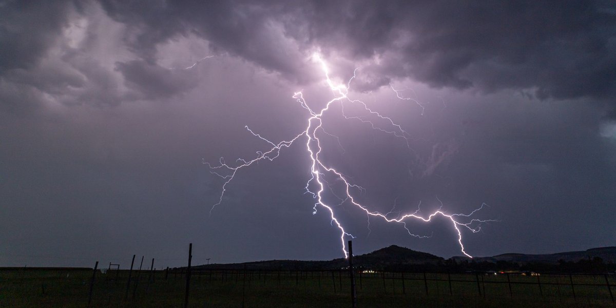
No matter the type, the safety rule is the same and it’s blunt: when thunder roars, go indoors. Lightning can strike up to 10 miles from a storm’s rain core, which means it can hit you under blue sky before the rain ever arrives. Wait 30 minutes after the last thunderclap before heading back out.
For the dangerous types, learn to read the sky. A low, arc-shaped shelf cloud bearing down on you means a squall line’s gust front is about to deliver a wall of wind — get inside. A storm with a rotating wall cloud, or one a watch has flagged as a supercell, deserves your full attention: have a way to receive warnings, and know where your interior, lowest-floor shelter is before the sky turns green.
Knowing the difference between a 20-minute pop-up and a rotating supercell isn’t just trivia. It’s the difference between watching the lightning from your porch and knowing exactly when it’s time to stop watching.