From mountain passes to coastal promenades, storms shape travel, crops and daily routines — knowing their differences matters whether you live near the sea or inland. A clear, concise list helps spot risks and plan responses without wading through jargon.
There are 25 Types of Storms, ranging from Blizzard to Waterspout. For each, you’ll find below Cause (mechanism):Main physical cause or mechanism (max 15 words),Season/region:Typical season and regions (max 15 words),Typical intensity (km/h) or scale:Typical wind speed or relevant scale (use km/h, mm/hr or named scale),Description:30-50 word conversational description including a notable example and why it is notable — you’ll find below.
How can I quickly tell which storm is approaching my area?
Check the forecast for wind speed, precipitation type and movement: snow-heavy, low temps point to blizzard risk, rotating clouds and water over warm seas hint at waterspouts. Local warnings and radar provide the fastest, most reliable identification.
Which storms cause the most immediate danger to people and property?
High-wind events (hurricanes, tornadoes), coastal surge, and rapid flash-flooding are the most acute threats; snowstorms and blizzards pose prolonged danger via isolation and hypothermia. Always follow official watches and evacuation guidance for the best protection.
Types of Storms
| Name:Most common short name of the storm type | Cause (mechanism):Main physical cause or mechanism (max 15 words) | Season/region:Typical season and regions (max 15 words) | Typical intensity (km/h) or scale:Typical wind speed or relevant scale (use km/h, mm/hr or named scale) | Description:30-50 word conversational description including a notable example and why it is notable |
|---|---|---|---|---|
| Tropical cyclone | Warm ocean, low pressure, organized convection | Warm-season tropics worldwide | 63-250 km/h (tropical storm to major hurricane) | A rotating low-pressure system over warm oceans fueled by moist convection. Can produce hurricane-force winds, storm surge and heavy rain. Notable: 2005 Hurricane Katrina, notable for catastrophic storm surge and widespread flooding in New Orleans and Gulf Coast. |
| Hurricane (Atlantic) | Tropical cyclone over warm Atlantic waters | June–November, Atlantic and eastern Pacific | 119-250 km/h (Category 1-5) | Hurricane is the Atlantic name for intense tropical cyclones producing extreme winds, rain and storm surge. Notable: 2017 Hurricane Maria devastated Puerto Rico, causing island-wide power loss, catastrophic damage and a prolonged humanitarian crisis. |
| Typhoon (NW Pacific) | Tropical cyclone over warm NW Pacific waters | Year-round, peak Jun–Nov western Pacific | 119-250 km/h (Category 1-5) | Typhoon is the northwest Pacific name for strong tropical cyclones with extreme winds and rainfall. Notable: 2013 Typhoon Haiyan had estimated winds over 315 km/h and catastrophic storm surge, causing thousands of deaths in the Philippines. |
| Cyclone (Indian/South Pacific) | Tropical cyclone over Indian/South Pacific | Oct–April in Indian/South Pacific regions | 119-250 km/h (Category 1-5) | Cyclone is regional name used in the Indian Ocean and South Pacific for tropical cyclones. Notable: 1970 Bhola Cyclone killed ~300,000 in Bangladesh, highlighting storm surge vulnerability in low-lying coasts. |
| Tropical storm | Organized tropical cyclone with lower winds | Tropical cyclone seasons in basins | 63-118 km/h (tropical storm) | Tropical storms are organized tropical cyclones with sustained winds below hurricane strength but still dangerous. Notable: Tropical Storm Allison (2001) caused catastrophic inland flooding in Houston despite never reaching hurricane strength. |
| Extratropical cyclone | Temperature contrasts along fronts, baroclinic instability | Year-round extratropics, strong in winter mid-latitudes | 50-150 km/h typical winds; pressure falls | Large-scale low-pressure systems driven by temperature contrasts along fronts. They bring strong winds, rain or snow and coastal flooding. Notable: The 1993 “Storm of the Century” produced blizzard conditions across eastern North America. |
| Nor’easter | Intense extratropical cyclone off U.S. East Coast | Fall–spring, U.S. East Coast and Atlantic Canada | Heavy snow or winds 60-160 km/h; coastal surge | Nor’easters are powerful coastal storms bringing heavy snow, wind and storm surge to the U.S. East Coast. Notable: the Blizzard of 1978 paralyzed New England with blizzard conditions, high tides and widespread damage. |
| Bomb cyclone (explosive cyclogenesis) | Rapid deepening of mid-latitude cyclone (pressure drop) | Fall–spring northern-hemisphere coasts | Rapid pressure drop; winds 80-160 km/h possible | A “bomb cyclone” undergoes explosive pressure deepening, quickly intensifying an extratropical storm. It can bring heavy snow, strong winds and coastal flooding. Notable: January 2018 U.S. bomb cyclone led to blizzard conditions and major travel disruptions. |
| Polar low | Small intense polar maritime cyclones from cold-air outbreak | Cold season, polar/subpolar oceans | 80-160 km/h winds; compact systems | Polar lows are compact, short-lived cyclones over cold seas with intense winds and heavy snow squalls. Notable: Polar lows produce sudden severe weather for ships and Arctic communities off Norway and Greenland. |
| Mesoscale convective system (MCS) | Clustered thunderstorms organized by mesoscale dynamics | Warm season mid-latitudes, tropics | Winds 60-140 km/h; heavy rain rates | An MCS is an extensive cluster of thunderstorms that can produce prolonged heavy rain, damaging winds and flooding. Notable: The 2013 Oklahoma MCS produced widespread damaging winds and flash floods across the Plains. |
| Squall line | Linear thunderstorm band from frontal forcing or outflow | Warm season mid-latitudes, tropics | Straight-line winds 80-140 km/h; hail, tornadoes | A squall line is a long line of thunderstorms that can produce intense straight-line winds, hail and occasional tornadoes. Notable: Squall lines in the U.S. Midwest often cause rapid wind damage and widespread power outages. |
| Derecho | Long-lived bowing convective line producing straight-line winds | Warm season mid-latitudes, especially central plains | Winds 100-160 km/h; widespread damage | A derecho is an extensive, long-lived convective windstorm producing continuous severe straight-line winds. Notable: The 2020 Midwest derecho caused enormous agricultural and infrastructure damage across Iowa with gusts over 140 km/h. |
| Thunderstorm | Atmospheric instability, moist rising air, convection | Warm season worldwide, especially tropics/mid-latitudes | Wind/gusts 60-120 km/h; heavy rain; lightning | Thunderstorms result from buoyant air and moisture rising to form cumulonimbus clouds, bringing lightning, heavy rain, and gusty winds. Notable: Lightning strikes from severe storms cause deaths and wildfires worldwide each year. |
| Severe thunderstorm (official) | Strong convection, wind shear and instability | Warm season mid-latitudes, continental interiors | Hail ≥2 cm, winds ≥90 km/h, tornado potential | A severe thunderstorm meets criteria for large hail, damaging winds, or tornadoes and poses major hazards. Notable: Severe storm outbreaks like the 2011 U.S. Super Outbreak produced hundreds of tornadoes and extreme damage. |
| Tornado | Rotating column from severe thunderstorm updrafts and shear | Warm season mid-latitudes, especially U.S. Great Plains | Wind 120-512 km/h (EF scale up to EF5) | A tornado is a violently rotating column of air from thunderstorms causing localized extreme damage. Notable: The 2011 Joplin tornado was an EF5, killing hundreds and causing catastrophic urban destruction. |
| Waterspout | Tornadic or fair-weather vortex over water from convection | Warm months over lakes/seas, tropics and coasts | Winds variable; tornadic up to 400 km/h possible | A waterspout is a rotating column over water, either tornadic or non-tornadic, dangerous to boats and coastal areas. Notable: Florida’s frequent waterspouts often threaten mariners and can move ashore as tornadoes. |
| Microburst | Intense downdraft from evaporative cooling in thunderstorms | Warm season worldwide, aviation hazard near storms | Winds 120-240 km/h over small areas | Microbursts are sudden, powerful downdrafts that strike the surface causing damaging divergent winds. Notable: Microbursts have downed aircraft on approach and are a major aviation safety concern near thunderstorms especially during summer convective storms. |
| Hailstorm | Strong updrafts in thunderstorms forming ice pellets | Warm season mid-latitudes, continental interiors | Hail sizes variable; destructive hail >2 cm common | Hailstorms produce balls of ice that can shatter glass, dent vehicles and damage crops. Notable: The 1987 Munich hailstorm produced enormous hail causing extensive property and agricultural losses across the region. |
| Blizzard | Strong winds with heavy snow and reduced visibility | Winter mid-latitudes, polar regions | Winds >40 km/h, visibility <400 m, prolonged | A blizzard combines heavy snow, strong winds and very low visibility, making travel deadly. Notable: The Great Blizzard of 1978 brought massive snow, paralysis and multiple fatalities across parts of the United States. |
| Lake-effect snow | Cold air over warmer lake water producing heavy localized snow | Late fall-winter near large lakes (Great Lakes) | Snow rates tens mm/hr; totals many cm localized | Lake-effect snow occurs when cold air passes over warmer lakes, producing intense narrow bands of heavy snow. Notable: Areas downwind of the Great Lakes routinely get localized dumps of over a metre of snow in a single storm. |
| Ice storm / Freezing rain event | Warm layer aloft melts snow, refreezes on contact | Winter, mid-latitudes with warm aloft profiles | Ice accretion mm; freezing rain 2–20 mm ice | Ice storms coat surfaces with glaze from freezing rain, bringing dangerous travel, power outages and tree damage. Notable: The 1998 North American ice storm caused massive prolonged power outages and infrastructure damage in Canada and the U.S. |
| Sleet storm | Cold surface below melting layer produces ice pellets | Winter mid-latitudes and high latitudes | Precip rate variable; pellets mm sizes | Sleet storms produce ice pellets (sleet) that bounce on impact, reducing visibility and making surfaces slippery. Notable: Northeastern U.S. sleet events can disrupt travel and sometimes accompany larger winter storms. |
| Snow squall | Intense convective snow bands from cold advection or lakes | Winter, Great Lakes and cold fronts | Visibility <400 m, heavy snow rates brief | Snow squalls are short-lived, intense bursts of heavy snow and whiteout conditions causing sudden hazardous travel. Notable: Lake-effect snow squalls have caused many multi-vehicle pileups on highways especially in winter. |
| Dust/sand storm (haboob) | Strong winds lifting loose dust/sand, convective outflows | Arid regions, deserts worldwide, warm season | Visibility <1,000 m; winds often 60-120 km/h | Dust or sandstorms (haboobs) kick up large plumes of dust reducing visibility, damaging machinery and harming respiratory health. Notable: Saharan dust storms can cross the Atlantic, affecting air quality in the Americas. |
| Monsoon storm | Seasonal shift in winds bringing concentrated moisture and convection | Summer monsoon regions: South Asia, SE Asia, West Africa | Heavy rainfall rates; flooding common | Monsoon storms are seasonal large-scale rains driven by wind reversals that deliver prolonged heavy rain and flooding. Notable: South Asian monsoons sustain agriculture but sometimes cause devastating floods and landslides. |
Images and Descriptions
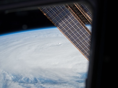
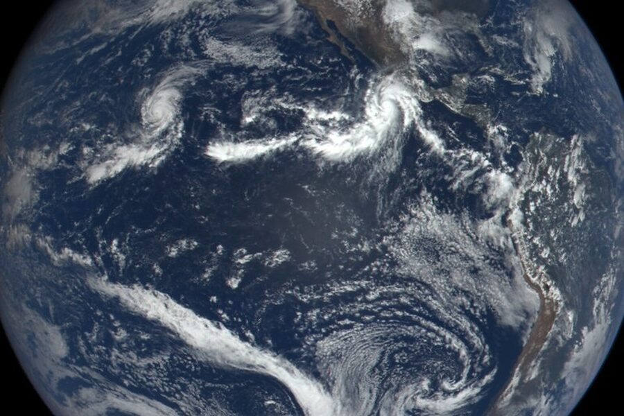
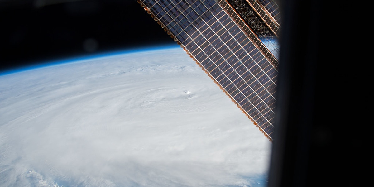
Tropical cyclone
A rotating low-pressure system over warm oceans fueled by moist convection. Can produce hurricane-force winds, storm surge and heavy rain. Notable: 2005 Hurricane Katrina, notable for catastrophic storm surge and widespread flooding in New Orleans and Gulf Coast.

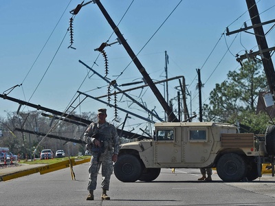
Hurricane (Atlantic)
Hurricane is the Atlantic name for intense tropical cyclones producing extreme winds, rain and storm surge. Notable: 2017 Hurricane Maria devastated Puerto Rico, causing island-wide power loss, catastrophic damage and a prolonged humanitarian crisis.
Typhoon (NW Pacific)
Typhoon is the northwest Pacific name for strong tropical cyclones with extreme winds and rainfall. Notable: 2013 Typhoon Haiyan had estimated winds over 315 km/h and catastrophic storm surge, causing thousands of deaths in the Philippines.

Cyclone (Indian/South Pacific)
Cyclone is regional name used in the Indian Ocean and South Pacific for tropical cyclones. Notable: 1970 Bhola Cyclone killed ~300,000 in Bangladesh, highlighting storm surge vulnerability in low-lying coasts.
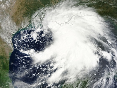
Tropical storm
Tropical storms are organized tropical cyclones with sustained winds below hurricane strength but still dangerous. Notable: Tropical Storm Allison (2001) caused catastrophic inland flooding in Houston despite never reaching hurricane strength.
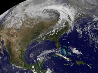
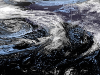
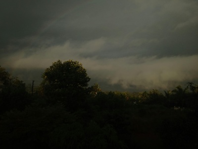
Extratropical cyclone
Large-scale low-pressure systems driven by temperature contrasts along fronts. They bring strong winds, rain or snow and coastal flooding. Notable: The 1993 “Storm of the Century” produced blizzard conditions across eastern North America.

Nor’easter
Nor’easters are powerful coastal storms bringing heavy snow, wind and storm surge to the U.S. East Coast. Notable: the Blizzard of 1978 paralyzed New England with blizzard conditions, high tides and widespread damage.
Bomb cyclone (explosive cyclogenesis)
A “bomb cyclone” undergoes explosive pressure deepening, quickly intensifying an extratropical storm. It can bring heavy snow, strong winds and coastal flooding. Notable: January 2018 U.S. bomb cyclone led to blizzard conditions and major travel disruptions.
Polar low
Polar lows are compact, short-lived cyclones over cold seas with intense winds and heavy snow squalls. Notable: Polar lows produce sudden severe weather for ships and Arctic communities off Norway and Greenland.
Mesoscale convective system (MCS)
An MCS is an extensive cluster of thunderstorms that can produce prolonged heavy rain, damaging winds and flooding. Notable: The 2013 Oklahoma MCS produced widespread damaging winds and flash floods across the Plains.
Squall line
A squall line is a long line of thunderstorms that can produce intense straight-line winds, hail and occasional tornadoes. Notable: Squall lines in the U.S. Midwest often cause rapid wind damage and widespread power outages.
Derecho
A derecho is an extensive, long-lived convective windstorm producing continuous severe straight-line winds. Notable: The 2020 Midwest derecho caused enormous agricultural and infrastructure damage across Iowa with gusts over 140 km/h.

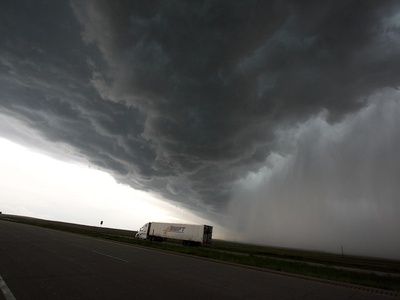
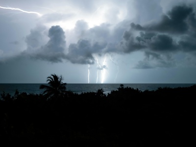
Thunderstorm
Thunderstorms result from buoyant air and moisture rising to form cumulonimbus clouds, bringing lightning, heavy rain, and gusty winds. Notable: Lightning strikes from severe storms cause deaths and wildfires worldwide each year.
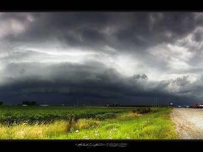
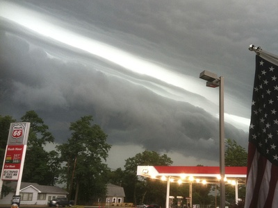
Severe thunderstorm (official)
A severe thunderstorm meets criteria for large hail, damaging winds, or tornadoes and poses major hazards. Notable: Severe storm outbreaks like the 2011 U.S. Super Outbreak produced hundreds of tornadoes and extreme damage.
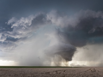
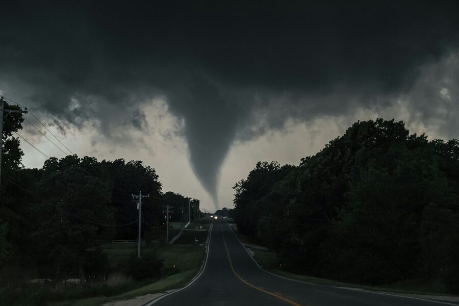
Tornado
A tornado is a violently rotating column of air from thunderstorms causing localized extreme damage. Notable: The 2011 Joplin tornado was an EF5, killing hundreds and causing catastrophic urban destruction.
Waterspout
A waterspout is a rotating column over water, either tornadic or non-tornadic, dangerous to boats and coastal areas. Notable: Florida’s frequent waterspouts often threaten mariners and can move ashore as tornadoes.
Microburst
Microbursts are sudden, powerful downdrafts that strike the surface causing damaging divergent winds. Notable: Microbursts have downed aircraft on approach and are a major aviation safety concern near thunderstorms especially during summer convective storms.
Hailstorm
Hailstorms produce balls of ice that can shatter glass, dent vehicles and damage crops. Notable: The 1987 Munich hailstorm produced enormous hail causing extensive property and agricultural losses across the region.

Blizzard
A blizzard combines heavy snow, strong winds and very low visibility, making travel deadly. Notable: The Great Blizzard of 1978 brought massive snow, paralysis and multiple fatalities across parts of the United States.
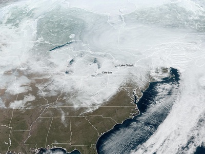
Lake-effect snow
Lake-effect snow occurs when cold air passes over warmer lakes, producing intense narrow bands of heavy snow. Notable: Areas downwind of the Great Lakes routinely get localized dumps of over a metre of snow in a single storm.

Ice storm / Freezing rain event
Ice storms coat surfaces with glaze from freezing rain, bringing dangerous travel, power outages and tree damage. Notable: The 1998 North American ice storm caused massive prolonged power outages and infrastructure damage in Canada and the U.S.
Sleet storm
Sleet storms produce ice pellets (sleet) that bounce on impact, reducing visibility and making surfaces slippery. Notable: Northeastern U.S. sleet events can disrupt travel and sometimes accompany larger winter storms.
Snow squall
Snow squalls are short-lived, intense bursts of heavy snow and whiteout conditions causing sudden hazardous travel. Notable: Lake-effect snow squalls have caused many multi-vehicle pileups on highways especially in winter.
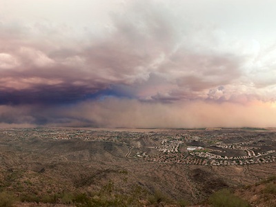
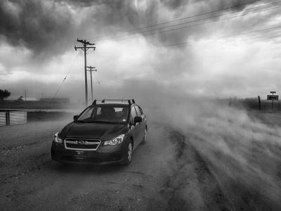
Dust/sand storm (haboob)
Dust or sandstorms (haboobs) kick up large plumes of dust reducing visibility, damaging machinery and harming respiratory health. Notable: Saharan dust storms can cross the Atlantic, affecting air quality in the Americas.
Monsoon storm
Monsoon storms are seasonal large-scale rains driven by wind reversals that deliver prolonged heavy rain and flooding. Notable: South Asian monsoons sustain agriculture but sometimes cause devastating floods and landslides.