New Zealand’s volcanic landscape is woven into its scenery and history, from coastal cones and lava domes to geothermal fields — these features shape towns, roads and outdoor recreation.
There are 52 Volcanoes in New Zealand, ranging from Akaroa Volcano (Banks Peninsula) to White Island (visitor access varies). Each entry lists Region,Elevation (m),Last eruption (year) so you can compare location, height and recent activity; you’ll find the full list below.
Which of these volcanoes are currently active?
A handful are classified as active and are monitored by GeoNet; activity can range from steam vents and micro-seismicity to eruptions. Notable active systems include Whakaari/White Island, Ruapehu and Tongariro, but conditions change — check GeoNet advisories and local restrictions before planning a visit.
Are these volcanoes open to visitors and are there safety rules?
Many are accessible via parks and guided tours, but access depends on land status, weather and hazard level — White Island has strict controls, some craters require guides or permits, and trails can close during unrest. Always follow Department of Conservation guidance, tour operator instructions and GeoNet warnings, and carry appropriate gear.
Volcanoes in New Zealand
| Name | Region | Elevation (m) | Last eruption (year) |
|---|---|---|---|
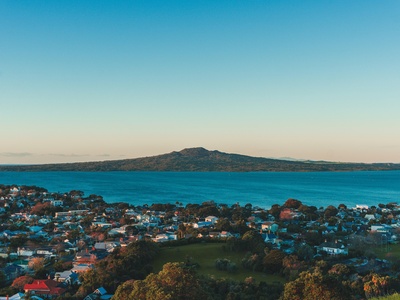
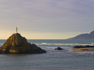
| Rangitoto | Auckland | 260 | c.1400 AD |
| Maungawhau (Mount Eden) | Auckland | 196 | Prehistoric |
| Maungakiekie (One Tree Hill) | Auckland | 182 | Prehistoric |
| Maungarei (Mount Wellington) | Auckland | 135 | Prehistoric |
| Mangere Mountain | Auckland | 106 | Prehistoric |
| Puketāpapa (Mount Roskill) | Auckland | 141 | Prehistoric |
| Auckland Volcanic Field | Auckland | 260 | c.1400 AD |
| Taupō (Lake Taupō caldera) | Taupo Volcanic Zone | 357 | 232 AD |
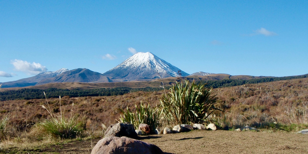
| Mount Ruapehu | Tongariro | 2,797 | 2007 AD |
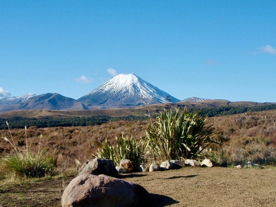
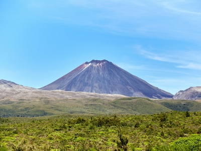
| Mount Ngauruhoe | Tongariro | 2,291 | 1975 AD |
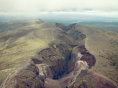
| Mount Tongariro | Tongariro | 1,978 | 2012 AD |
| Okataina Volcanic Centre | Taupo Volcanic Zone | 309 | 1886 AD |
| Mount Tarawera | Okataina / Bay of Plenty | 1,111 | 1886 AD |
| Rotorua Caldera | Rotorua | 280 | Prehistoric |
| Mount Tauhara | Taupo | 1,088 | Prehistoric |
| Whakaari / White Island | Bay of Plenty (offshore) | 321 | 2019 AD |
| Mayor Island / Tuhua | Bay of Plenty | 355 | Prehistoric |
| Motuhora (Whale Island) | Bay of Plenty | 163 | Prehistoric |
| Putauaki / Mount Edgecumbe | Bay of Plenty | 820 | Prehistoric |
| Mount Taranaki / Egmont | Taranaki | 2,518 | Prehistoric |
| Mount Taranaki (LaHar risk note) | Taranaki | 2,518 | Prehistoric |
| Banks Peninsula volcanic complex | Canterbury | 919 | Prehistoric |
| Dunedin Volcano (Otago) | Otago | 676 | Prehistoric |
| Great Barrier Island (Aotea) volcanic complex | Auckland | 621 | Prehistoric |
| Motutapu Island | Auckland | 177 | Prehistoric |
| Mauao (Mount Maunganui) | Bay of Plenty | 232 | Prehistoric |
| Raoul Island | Kermadec Islands | 516 | 2006 AD |
| Macauley Island | Kermadec Islands | 370 | Prehistoric |
| Havre Seamount | Kermadec / NZ EEZ | 0 | 2012 AD |
| Monowai Seamount | Kermadec Arc / EEZ | 0 | Unknown |
| Mount Pirongia | Waikato | 959 | Prehistoric |
| Mount Karioi | Waikato | 456 | Prehistoric |
| Mount Ngongotaha | Rotorua | 757 | Prehistoric |
| Mount Taranaki (visitor note) | Taranaki | 2,518 | Prehistoric |
| Mount Moehau | Coromandel Peninsula | 892 | Prehistoric |
| Mount Kakepuku | Waikato | 449 | Prehistoric |
| Mount Hikurangi (non-volcanic note) | Gisborne | 1,752 | Unknown |
| White Island (visitor access note) | Bay of Plenty (offshore) | 321 | 2019 AD |
| Taupo Volcanic Zone (region summary) | North Island | 0 | — |
| Coromandel Volcanic Zone (ancient) | Coromandel / Hauraki | 0 | Prehistoric |
| Mount Tuhua (Mayor Island note) | Bay of Plenty | 355 | Prehistoric |
| Okarito volcanic remnants | West Coast | 0 | Prehistoric |
| Rangipo Desert volcanic area | Central North Island | 0 | Prehistoric |
| Taupo Caldera (visitor note) | Taupo Volcanic Zone | 357 | 232 AD |
| Kermadec arc (overview) | Kermadec / NZ EEZ | 0 | Ongoing geological activity |
| Rangipo Cone | Tongariro | 1,800 | Prehistoric |
| Ngāuruhoe (climbing hazard reminder) | Tongariro | 2,291 | 1975 AD |
| Taupo Geothermal Features (overview) | Taupo / Rotorua | 0 | Ongoing hydrothermal |
| Harbour volcanoes (southern lakes) | South Island | 0 | Prehistoric |
| Akaroa Volcano (Banks Peninsula detail) | Canterbury | 500 | Prehistoric |
| Otago Peninsula volcanic features | Otago | 0 | Prehistoric |
| Rangitata volcanic remnants | Canterbury | 0 | Prehistoric |
Images and Descriptions
Rangitoto
Young, iconic shield volcano forming Rangitoto Island off Auckland. Visible from the city, it erupted about 600 years ago and is a popular day-hike with lava caves; hazards are minimal now but Auckland staff monitor future city-field activity.

Maungawhau (Mount Eden)
Central city dormant scoria cone with a large crater and panoramic views. Maungawhau is a cultural landmark and easy urban walk; eruptions were prehistoric but future small eruptions could create new cones in the Auckland field.
Maungakiekie (One Tree Hill)
Historic volcanic cone crowned by a memorial park and crater terraces. One Tree Hill is an Auckland cultural site with easy access; eruptive activity is prehistoric but the cone illustrates Auckland’s monogenetic volcanic field hazards for housing and infrastructure.
Maungarei (Mount Wellington)
Prominent eastern Auckland scoria cone with walking tracks and suburban views. Long extinct but part of the Auckland volcanic field; notable for accessible parks, playgrounds and reminders that the city sits on many dormant volcanic cones.
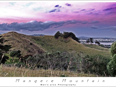
Mangere Mountain
Large, grassy volcanic cone south of central Auckland with walking tracks and pā terraces. Extinct for thousands of years and now a recreation reserve — a good site to learn about Auckland’s frequent, small-scale eruptions.
Puketāpapa (Mount Roskill)
Small, accessible volcanic dome with a park on Auckland’s western ridge. Extinct monogenetic cone with archaeological features and panoramic city views; illustrates local volcanic history with minimal visitor hazard.
Auckland Volcanic Field
Urban volcanic field of ~50–60 small cones and lava flows including Rangitoto. Eruptions are typically single-event cones; the field is dormant but unextinguished — future eruptions could occur beneath suburbs, making planning and monitoring vital.
Taupō (Lake Taupō caldera)
Huge caldera formed by the AD 232/Hatepe eruption, one of the world’s largest historic eruptions. Lake Taupō is a major tourist destination; future VEI-scale eruptions are possible though unlikely soon, but ash and pyroclastic flows are the key hazards.
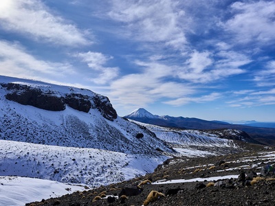
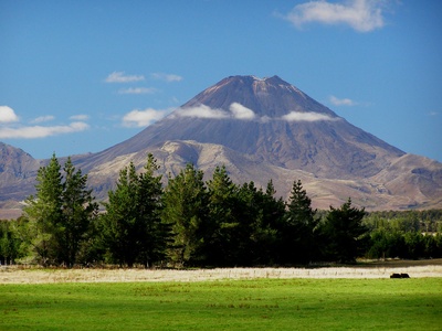
Mount Ruapehu
New Zealand’s highest active cone, with ski fields and a crater lake. Frequent eruptions and lahars pose real hazards to visitors and downstream communities; closely monitored, it last erupted in 2007 and remains the most volcanically active large stratovolcano in the North Island.
Mount Ngauruhoe
Conical active vent often considered a separate mountain though technically part of Tongariro. Famous from films and backcountry skiing, it last erupted in the 1970s; small eruptions and ballistic ejecta make it hazardous to climb when active.
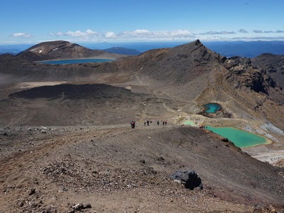
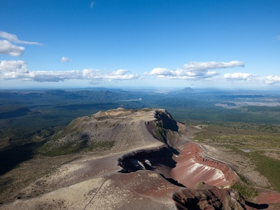
Mount Tongariro
Complex volcanic massif with multiple vents; 2012 Te Māri crater eruptions underlined its active status. Popular Tongariro Alpine Crossing traverses volcanic terrain — visitors must heed closures and ash/steam hazards during unrest.
Okataina Volcanic Centre
Highly active rhyolitic caldera complex that includes Tarawera and numerous vents. It produced large explosive eruptions; the 1886 Tarawera event was devastating. Okataina is closely monitored for ash risk and geothermal hazards.
Mount Tarawera
Site of the dramatic 1886 eruption that destroyed villages and changed local landscapes. Tarawera’s fissure eruptions created spectacular craters and remains a key cultural and geological site; access is seasonal and guided visits are common.
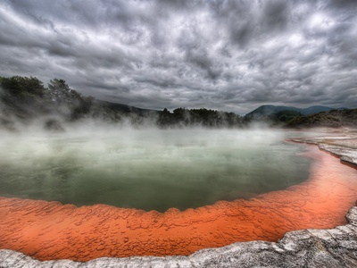
Rotorua Caldera
Large geothermal caldera underlying Rotorua township with hot springs, geysers and ongoing geothermal hazards. Eruptions are mostly prehistoric but hydrothermal activity affects visitor safety; the area is a major tourist and cultural attraction with active monitoring.
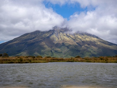
Mount Tauhara
Conspicuous volcanic dome east of Taupō offering short hikes and lake views. Long extinct but scenic and culturally significant; no recent activity, though it illustrates Taupō region’s violent volcanic past.
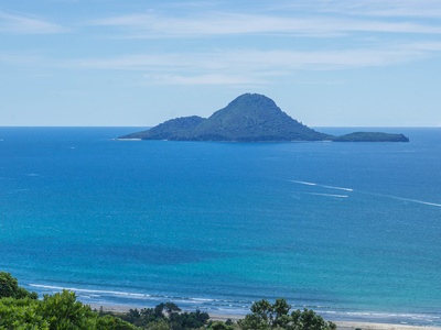
Whakaari / White Island
Active marine stratovolcano in the Bay of Plenty, famous and dangerous — the 2019 eruption caused fatalities. Popular but high-risk tourist visits are tightly controlled; ongoing gas and eruption hazards make it one of NZ’s most closely watched volcanoes.
Mayor Island / Tuhua
Dome-shaped rhyolite island with sparkling obsidian and rugged coastline. Extinct for thousands of years; notable for geology, birdlife and day-visit anchorage. Volcano presents minimal immediate risk but is an exceptional example of rhyolitic island volcanism.
Motuhora (Whale Island)
Small volcanic island near Whakatāne with wildlife reserve status; formed by scoria and lava. Extinct and accessible only by permit; safe for day visitors but sensitive ecologically and geologically.
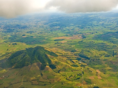
Putauaki / Mount Edgecumbe
Prominent symmetrical cone near Kawerau/Whakatāne, visible from surrounding plains. Extinct in recent times and culturally significant; accessible by guided tours in good conditions, with steep slopes popular with experienced hikers.
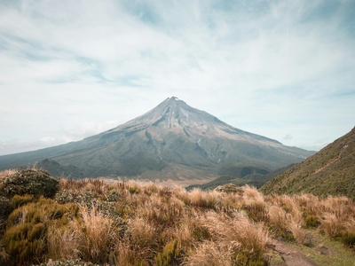
Mount Taranaki / Egmont
Striking symmetrical stratovolcano dominating the west coast, with alpine hiking and lush forest park. Last eruptions were prehistoric but future activity could produce lahars and pyroclastic flows; the mountain is a strong cultural icon with well-managed access tracks.
Mount Taranaki (LaHar risk note)
Dominant volcanic peak with steep valleys prone to lahars during eruptions. Popular with hikers and mountaineers; emergency planning addresses lahar hazards to surrounding communities and infrastructure.
Banks Peninsula volcanic complex
Ancient pair of lavas and explosive centers forming Lyttelton and Akaroa harbours near Christchurch. Extinct for millions of years, the scenic craters and harbours are major visitor attractions and illustrate long-ago shield and explosive volcanism on the South Island.
Dunedin Volcano (Otago)
Ancient basaltic volcanic complex that formed much of the Otago Peninsula and rises around Dunedin. Extinct for millions of years, it’s now valued for geology and coastal scenery; no modern volcanic hazard but important for regional landscape history.
Great Barrier Island (Aotea) volcanic complex
Large extensional volcanic island east of Auckland with rugged peaks and walking tracks. Extinct in the geological past; visitor access by ferry or plane with remote backcountry experiences and rich volcanic landforms to explore.
Motutapu Island
Volcanic island joined to Rangitoto by a tombolo; older than Rangitoto with archaeological sites and regenerating bush. Extinct; popular for day trips, walking and learning about successive volcanic episodes in the Hauraki Gulf.
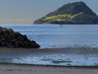
Mauao (Mount Maunganui)
Iconic harbour headland at Tauranga with easy summit walks and panoramic ocean views. A volcanic dome and cultural landmark; long extinct but heavily visited — hazards are limited to normal coastal and track safety.
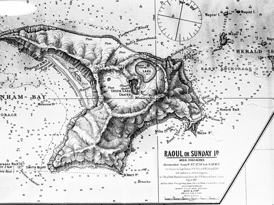
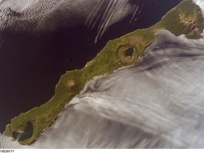
Raoul Island
Largest Kermadec Island with frequent volcanic and seismic activity; eruptions and unrest have occurred in recent decades. Remote but monitored; the island has a rugged landscape, seabird colonies and restricted access due to volcanic risk.
Macauley Island
Rugged volcanic island in the Kermadec chain with steep cliffs and caldera features. Extinct in recent times but formed by large volcanic events; visited only by researchers with biosecurity controls due to unique ecosystems.
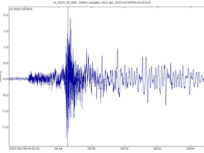
Havre Seamount
Submarine rhyolitic volcano that produced a massive 2012 eruption with a huge pumice raft observed at sea. Submarine activity can create maritime hazards; located in NZ’s EEZ and monitored as part of Kermadec arc studies.
Monowai Seamount
Very active submarine volcano in the southern Kermadec arc known for frequent eruptions and rapid morphological change. Located offshore in NZ’s EEZ; hazards are primarily maritime (pumice, tsunamis from flank collapse) rather than land-based.
Mount Pirongia
Large, forested basaltic stratovolcano west of Hamilton with tracks and cultural significance. Extinct for many thousands of years; offers accessible hikes and panoramic views while illustrating the region’s volcanic past.
Mount Karioi
Coastal volcanic cone near Raglan with steep cliffs and native forest. Extinct and popular for walking and birdlife; its rugged slopes and cultural sites make it a notable examples of coastal volcanic islands and cones.
Mount Ngongotaha
Prominent rhyolitic dome overlooking Rotorua with scenic tracks and views. Extinct for millennia but part of the Rotorua volcanic region; popular for recreation and local history, with geothermal features nearby.
Mount Taranaki (visitor note)
World-class alpine recreation site with well-maintained trails, but volcanic status means emergency planning exists for lahars and ash; visitors should check conditions and forecasted volcanic alerts before ascent.
Mount Moehau
Highest Coromandel peak, part of an extinct volcanic range with rugged forested terrain. No historical eruptions; an attractive but remote hiking destination illustrating long-ago volcanic activity that shaped the peninsula.
Mount Kakepuku
Distinctive basaltic cone near Te Awamutu with walking tracks and pā sites. Extinct for thousands of years and visible from nearby plains; small-scale cone volcano commonly visited for short hikes and cultural interpretation.
Mount Hikurangi (non-volcanic note)
Included to clarify: Mount Hikurangi is non-volcanic (a greywacke uplift) and therefore excluded from volcanic listings; visitors should note many named peaks in NZ are not volcanic in origin.
White Island (visitor access note)
Active island volcano with strict access controls following the 2019 tragedy; daily conditions can change rapidly and only licensed operators can visit when authorities allow — do not approach without authorization.
Taupo Volcanic Zone (region summary)
Broad, active volcanic belt hosting Taupō, Okataina, Tongariro and Rotorua systems. Not a single peak but a region of calderas, vents and geothermal features; it’s New Zealand’s most volcanically active area with significant ash and eruption hazards.
Coromandel Volcanic Zone (ancient)
Ancient volcanic province now mostly eroded; produced rhyolitic domes and ignimbrites that formed the Coromandel Range. No historic activity but important for scenic landscapes and geothermal remnants visited widely.
Mount Tuhua (Mayor Island note)
Mayor Island (Tuhua) is a rhyolite dome island known for obsidian and rich ecology; extinct in the recent past and accessible by permit — valuable for geology, conservation and cultural resources.
Okarito volcanic remnants
Scattered volcanic remnants on the West Coast dating to ancient episodes of volcanism; these form coastal features and isolated hills, with no modern hazard but of interest to geologists and scenic drives.
Rangipo Desert volcanic area
High-altitude volcanic plateau between Tongariro and Ruapehu with scoria cones and lava flows. Historically active during glacial periods; currently inhospitable, used for military training and backcountry travel with eruption monitoring in place.
Taupo Caldera (visitor note)
Lake Taupō area offers boating, fishing and thermal features; the caldera is a reminder of explosive potential — monitoring and emergency planning focus on ash, pyroclastics and lake tsunamis from large events.
Kermadec arc (overview)
Long arcuate chain of submarine and island volcanoes northeast of NZ; hosts frequent submarine eruptions and island unrest. Remote and monitored remotely; key source of maritime volcanic hazards and scientific interest.
Rangipo Cone
Series of basaltic cones on the Rangipo Desert plateau with lava flows and fissures. Extinct in recent centuries but part of the wider Tongariro volcanic system — rugged terrain used for recreation under variable conditions.
Ngāuruhoe (climbing hazard reminder)
While an iconic conical peak, Ngauruhoe remains a vent of Tongariro and can be hazardous during unrest; climbers should avoid steep crater rims and follow official alerts and track closures.
Taupo Geothermal Features (overview)
Extensive hot springs, fumaroles and geysers in the Taupō and Rotorua areas illustrate ongoing heat flow. Hazards are hydrothermal eruptions, burns and ground instability — stick to boardwalks and follow signage.
Harbour volcanoes (southern lakes)
Small, extinct volcanic centers that formed some southern lake basins; no modern activity but of regional geological interest and scenic value for low-impact tourism and study.
Akaroa Volcano (Banks Peninsula detail)
One of the two main Banks Peninsula centers, forming Akaroa Harbour with steep crater rims and wildlife. Extinct for millions of years; now a scenic tourist destination with historic French settlement and visitor walks.
Otago Peninsula volcanic features
Series of extinct volcanic centres that built the Otago Peninsula around Dunedin, producing basaltic lavas and cliffs. No eruption hazard but significant for wildlife, golf courses and coastal drives.
Rangitata volcanic remnants
Scattered ancient volcanic remnants in inland Canterbury shaping local hills and rock outcrops. Extinct; visited by geologists and walkers interested in the long-term volcanic history of the South Island.