In 2005 the Atlantic basin produced 28 named storms, a record season capped by Hurricane Katrina in August, which killed roughly 1,800 people and caused nearly $125 billion in damage—one of the most destructive examples of what a hurricane can do. That season forced changes in evacuation planning, disaster funding, and how agencies like NOAA communicate risk. You should care because lives, homes, critical infrastructure, and local economies depend on accurate science and clear warnings. Hurricanes are complex, powerful systems with surprising behaviors — understanding eight key facts about hurricanes helps people prepare, informs policy, and shows how climate and technology shape storm risk.
How Hurricanes Form and Structure
What counts as a hurricane and how it’s built matters for forecasting and damage. A hurricane is a tropical cyclone with sustained winds of at least 74 mph, and its basic anatomy—the eye, the eyewall, and spiral rainbands—helps explain why some storms devastate a narrow strip of coast while others flood wide inland areas. Satellites and NOAA cross-sections reveal structure that forecasters watch closely to anticipate intensity changes and impact patterns.
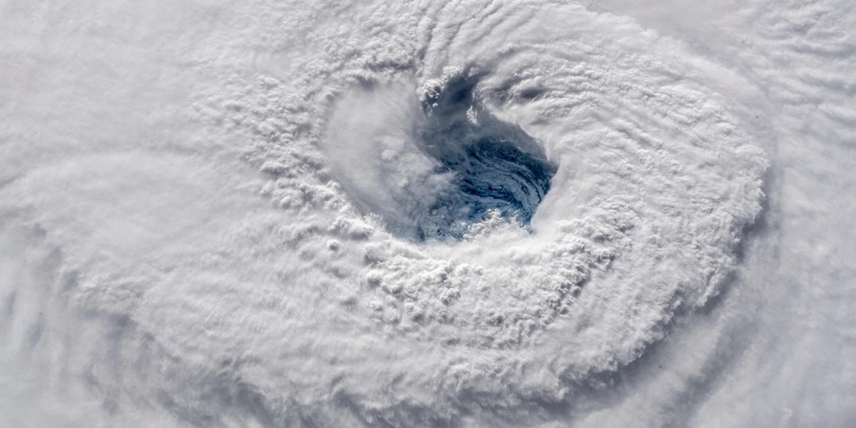
1. The Eye and Eye Wall: Calm Center, Intense Ring
The eye is often calm and can be surprisingly clear, but it’s ringed by the eyewall, where the storm’s strongest winds and heaviest rain live. Typical eye diameters range from about 10 to 40 miles, though compact “pinhole” eyes can be much smaller and linked to extreme winds.
In storms like Hurricane Wilma (2005), a very small eye coincided with extraordinary intensity; eyewall winds in major hurricanes can exceed 150 mph. For people, passing into the eye can give a false sense of safety—then the eyewall returns and brings the worst conditions. NOAA and NHC satellite imagery and aircraft observations routinely monitor eyewall structure because it concentrates most structural damage and guides evacuation priorities.
2. Hurricanes Feed Off Warm Ocean Waters
Hurricanes draw their energy from the ocean. Sea-surface temperatures around 26.5°C (about 80°F) or warmer favor development, and the depth of that warm layer—ocean heat content—matters too. A deep warm layer prevents cool water from upwelling beneath the storm, allowing sustained intensification.
Record-warm ocean conditions in seasons such as 2015 and 2020 helped fuel powerful storms. Hurricane Patricia (2015) is a striking case: it underwent explosive strengthening over very warm waters and reached estimated sustained winds near 215 mph at peak intensity. When storms move over colder water or over land they typically weaken, which is why coastal sea temperatures and ocean heat maps are essential inputs to forecasts.
3. Rotation Comes from the Coriolis Effect
The spin that organizes thunderstorms into a rotating cyclone comes from the Coriolis effect. That force is too weak near the equator, which explains why hurricanes generally don’t form within about 5° of latitude of the equator.
Rotation direction flips with hemisphere: counterclockwise in the Northern Hemisphere and clockwise in the Southern Hemisphere. That rotation combines with large-scale steering currents to shape storm tracks and the eventual landfall locations meteorologists forecast using global and regional models.
Measuring and Predicting Hurricanes
Meteorologists rely on satellites, aircraft, buoys, and radar to measure storms, then feed those observations into computer models. Observations and computing advances have cut track errors substantially, though predicting intensity changes remains difficult. The tools and scales used affect both public messaging and operational decisions during a threat.
4. The Saffir–Simpson Scale Rates Wind, Not Flooding
The Saffir–Simpson Hurricane Wind Scale classifies storms by sustained wind speed into categories 1 through 5; it does not measure storm surge or rainfall. Category thresholds include Category 1 at 74–95 mph and Category 5 at 157 mph or greater.
Because the scale focuses on wind, it can mislead people about overall danger. Hurricane Sandy (2012), for example, produced catastrophic flooding despite lower peak winds at U.S. landfall. Effective public messaging therefore pairs category information with surge, rainfall, and evacuation guidance from agencies like NOAA and local emergency managers.
5. Aircraft Reconnaissance — The ‘Hurricane Hunters’ Provide Crucial Data
NOAA and the U.S. Air Force fly specialized aircraft into storms to collect measurements satellites can’t provide. Aircraft types include NOAA’s WP-3D Orion and the high-altitude G-IV; historically P-3s have been workhorses for reconnaissance missions.
Flights deploy dropsondes that record vertical profiles of pressure, temperature, humidity, and winds as they descend. Dozens of missions may occur in an active season to support forecasts. Those in-situ observations improve model initial conditions and thus both track and intensity forecasts, especially when combined with satellite and buoy data.
6. Forecasts Have Improved — Especially Track Predictions
Over the last few decades average track errors for 72-hour forecasts have fallen dramatically thanks to better observations, data assimilation, and higher-resolution models. NOAA/NHC statistics show roughly a halving of certain forecast errors compared with the 1990s.
Intensity forecasting remains more uncertain because small-scale processes inside the storm—like eyewall replacement and internal convective bursts—can rapidly change strength. New approaches, including ensemble forecasting and machine-learning tools, are improving probabilistic guidance and helping emergency managers plan with longer lead times.
Impacts, Surprising Behaviors, and Safety
Winds grab headlines, but storm surge, extreme rainfall, and tornadoes spawned by hurricanes often cause the greatest harm. Unexpected behaviors such as rapid intensification can compress warning time, while heavy rains can flood inland communities far from the coast.
7. Rapid Intensification Can Happen Very Quickly
Rapid intensification is defined as an increase in maximum sustained winds of at least 35 mph within 24 hours. That threshold helps forecasters standardize what counts as explosive strengthening.
Examples include Hurricane Patricia (2015), which strengthened extraordinarily over hot water, and Hurricane Michael (2018), which deepened rapidly before Gulf Coast landfall. Factors that favor rapid intensification include pockets of very warm ocean heat content, low vertical wind shear, and moist mid-level air. When rapid intensification happens near landfall it shortens the window for safe evacuations and complicates preparedness plans.
8. Storm Surge and Inland Flooding Cause the Most Damage and Deaths
Historically, storm surge and freshwater flooding account for the majority of hurricane-related fatalities and much of the economic damage. Surge can flood coastal zones rapidly and push seawater far inland, undermining homes, roads, and protective dunes.
Hurricane Katrina (2005) produced catastrophic surge and levee failures that inundated New Orleans; Hurricane Harvey (2017) dropped unprecedented rainfall over Houston, producing prolonged inland flooding. These events show why coastal building codes, evacuation zones, and floodplain planning must account for both surge and extreme rainfall, using guidance from NOAA and USGS flood models.
Summary
Key takeaways that matter when a storm approaches:
- Warm oceans and deep heat content fuel stronger storms; monitoring sea-surface temperatures helps anticipate intensity.
- Rapid intensification is defined as a ≥35 mph rise in 24 hours and can dramatically shorten preparation time.
- The Saffir–Simpson scale rates only wind speed; surge and rainfall often drive fatalities and damage, so heed surge and flood warnings.
- Aircraft reconnaissance, satellites, and improved models have cut track errors, giving communities more time to act—but intensity forecasts remain challenging.
- These facts about hurricanes point to practical steps: follow NOAA/NHC advisories, respect evacuation orders, and support local flood- and coastal-planning efforts.