In 1825, the Stockton and Darlington Railway demonstrated early large-scale civil engineering—and accurate surveying tools were essential to laying its tracks on the intended route.
Fast forward two centuries and the instruments civil engineers rely on have changed a lot, but the fundamentals haven’t: accuracy, speed, compliance, and safety still decide whether a project succeeds or rolls into costly rework.
This piece breaks eight essential tools into four practical categories—surveying and positioning, leveling and layout, material testing and site investigation, and design plus imaging—so you get concrete examples, specs, and real-world uses for each one.
Understanding these eight tools helps you see how projects move from survey to finished structure.
Surveying & Positioning Tools
Precise positioning and angle/distance measurement are the foundation of any site work. From the theodolites of old to modern electronic instruments, survey control defines where everything goes—curbs, piles, utilities, and building lines.
Accuracy targets vary by task: control networks may need meter-to-millimeter precision, staking tolerances often land in the 5–50 mm range, and high-precision tasks push to sub-centimeter or even millimeter levels. Modern gear often ties directly into CAD or BIM, so measurements flow straight into design models without manual transcription errors.
Two tools in this group dramatically cut layout time and improve accuracy: the total station and GNSS/RTK receivers. Manufacturers like Leica, Trimble, and Topcon dominate the market, and open-site RTK solutions can deliver 1–2 cm positioning for rapid control establishment.
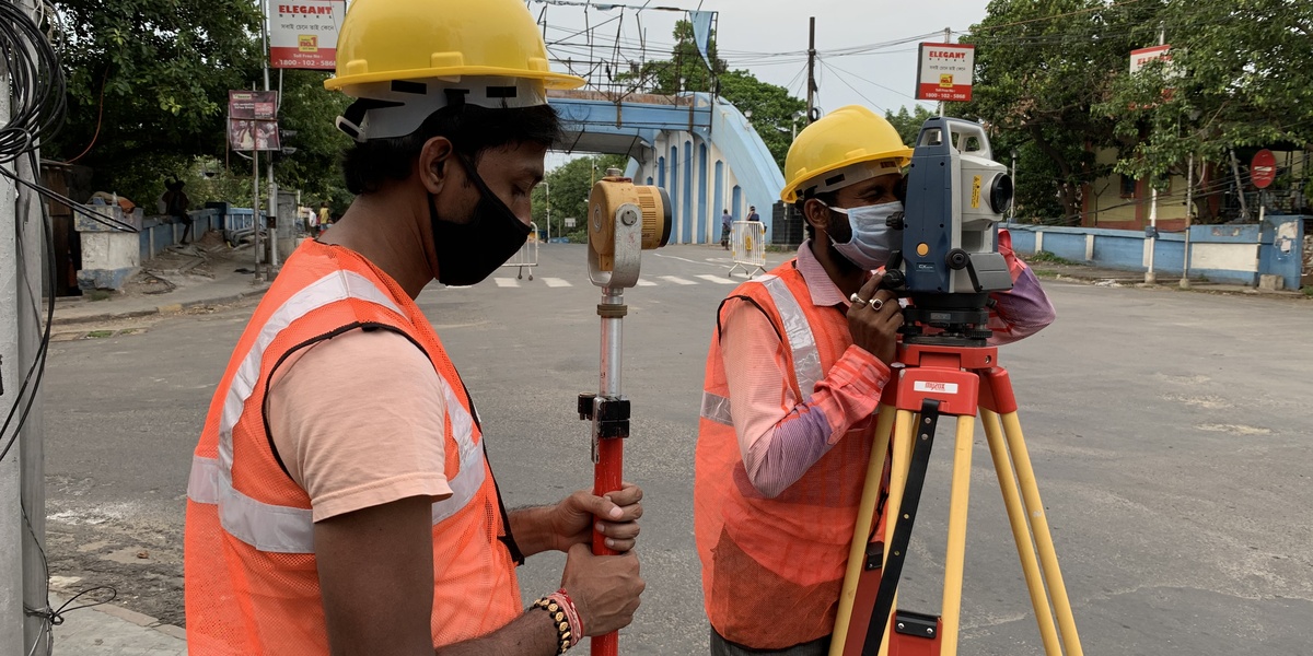
1. Total Station (Electronic Theodolite + EDM)
A total station measures horizontal and vertical angles plus slope distances using an electronic distance meter (EDM). It replaces older optical setups with digital readouts and data logging.
Modern total stations achieve angle accuracies down to 1 arc-second and distance accuracies to a few millimeters over hundreds of meters. Robotic models let a single operator run survey control and stakeout tasks that once required two or three people.
Common uses include site control, stakeout, topographic surveys, and as-built verification. Examples include the Leica Nova TS series (robotic models like the TS16) and Trimble S-Series. These units integrate with survey controllers and export points directly to AutoCAD or Civil 3D formats. For specs and procedures, see ISO 17123 and local surveying standards.
2. GNSS/GPS Receivers (RTK and Network RTK)
GNSS receivers with RTK or network RTK corrections produce centimeter-level horizontal positions on open sites. They’re ideal for fast, large-area work and for establishing primary control networks.
Typical RTK precision is about 1–2 cm horizontally; vertical precision is often a little worse but still useful for many layout tasks. Post-processing can improve vertical results for certain projects.
Use cases include corridor mapping, large topographic surveys, and rapid control point setup. Examples: Leica GS18 T (tilt compensation), Trimble R10, and Topcon HiPer series. Keep in mind GNSS performance drops under heavy canopy or between tall buildings, so hybrid workflows—GNSS plus total station—are common. Refer to national geodetic agencies for control-line best practices.
Leveling & Layout Equipment

Controlling elevation and layout on site depends on robust leveling and angle tools. Good grade control reduces rework, saves material, and keeps schedules on track.
Fine-grade work commonly targets ±5–10 mm; typical earthwork tolerances are wider. Laser systems speed grade setting and let operators keep tight tolerances across large areas, often connecting directly to machine-control systems.
This category focuses on two widely used layout tools that save hours of labor and cut mistakes on foundations, slabs, and earthworks.
3. Laser Level / Rotating Laser
Laser levels—either line lasers for interiors or rotating lasers for exterior work—project a reference plane for grade and plumb control. They’re fast and easy to set up.
Depending on the model and setup, grade tolerances from lasers range from sub-centimeter for fine tasks to about a centimeter for typical site layouts. Studies and jobsite reports commonly show layout time cut by 30–60% when crews use rotating lasers versus traditional optical levels.
Applications include setting formwork, checking slab elevations, plumbing tall columns, and tying into automatic machine guidance on graders and dozers. Examples: Topcon RL-H5A for rugged rotating-laser work and Bosch GLL series for interior alignments. Use handheld laser receivers on exterior sites for long-range visibility.
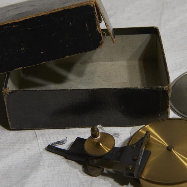
4. Optical Theodolite (and Manual Angle Instruments)
Optical theodolites are precision instruments for measuring angles and were the backbone of surveying for over a century. Electronically read theodolites and total stations have largely replaced them in daily fieldwork.
They still serve a purpose: calibration checks, teaching surveying fundamentals, and reconciling legacy control networks recorded with optical methods. You’ll still find Wild and older Leica optical theodolites in school labs and some offices.
Knowing how the theodolite works helps teams interpret older survey records and validate modern instruments during critical control surveys.
Material Testing & Site Investigation

Verifying material properties keeps structures safe and code-compliant. Field tests tell you when to strip formwork, accept a pavement lift, or call for corrective work.
Accepted test methods live in standards such as ASTM and EN. Turnaround for field checks runs from minutes (slump, density) to 24–48 hours or longer for lab-cured strengths.
Two everyday instruments give teams confidence: quick concrete checks and in-place density verification for soils and aggregates.
5. Concrete Slump Test & Compression Testing Equipment
The slump test (ASTM C143) is a quick field check of concrete consistency and workability. It’s done with a standard cone: 100 mm top diameter, 200 mm base, 300 mm height.
Compression testing machines verify strength per ASTM C39. Many structural concretes are designed to 25–40 MPa (about 3,600–5,800 psi), with the 28-day compressive test as the common benchmark.
Crews use slump tests to accept or reject batches on-site and cylinders or cubes to confirm long-term strength. Example equipment ranges from handheld slump kits to Controls or similar compression machines rated into the 1,000–2,000 kN range for laboratory verification.
6. Nuclear Density Gauge (and Field Compaction Testers)
Nuclear density gauges measure in-place soil density and moisture quickly, giving results in minutes so compaction acceptance decisions don’t stall the crew.
Typical acceptance criteria are expressed as a percentage of maximum dry density from a Proctor test—95% is common for road bases and embankments. Nuclear gauges like the Troxler 4640 and Humboldt models are standard on highways.
Where radioactive sources are restricted, teams use sand-cone tests, drive-cylinder methods, or modern nuclear-free density meters. Remember: nuclear gauges require certified operators and strict safety protocols under regulators such as the NRC in the U.S.
Design, Monitoring & Imaging Tools

Design and visualization tools bridge office and field: software models guide construction, while drones and scanners feed the models with timely site data.
BIM reduces clashes and supports quantity takeoffs; drones and LiDAR shorten survey schedules and give high-resolution context for decisions. Combined, they speed problem-solving and cut costly on-site surprises.
These tools used in civil engineering workflows include AutoCAD Civil 3D for corridor models, Revit for buildings, and drone-derived point clouds that update surface models in hours instead of days.
7. CAD and BIM Software (AutoCAD, Revit, Civil 3D)
CAD and BIM are the office side of construction—drawing, documenting, and producing quantities. AutoCAD first debuted in 1982; since then, model-based workflows have transformed how teams coordinate design and construction.
BIM supports clash detection, 4D scheduling, and digital handoffs to fabrication and subcontractors. Agencies in many countries now require BIM on major projects; adoption in developed markets often exceeds 50% for public works.
Use Civil 3D for road corridors and grading, Revit for multi-discipline building models, and Navisworks for coordination. These programs accept survey control, point clouds, and GNSS/total-station exports so field data stays in sync with design.
8. Drones (UAVs) and Photogrammetry / LiDAR
Drones equipped with photogrammetry cameras or lightweight LiDAR are high-productivity mapping tools. A single flight can cover several hectares in under an hour and produce orthomosaics with ground sampling distance under 5 cm/pixel when flown with RTK.
Applications include topographic surveys, stockpile volumes, progress documentation, and inspections of tall structures. Common platforms are DJI Phantom 4 RTK for high-resolution mapping, senseFly eBee for fixed-wing coverage, and Matrice platforms carrying LiDAR sensors.
Operators must follow local drone rules (FAA Part 107 in the U.S. or equivalent elsewhere), maintain line-of-sight unless authorized otherwise, and integrate orthomosaics and point clouds into Civil 3D or BIM to update surfaces and models rapidly.
Summary
- RTK GNSS and total stations now offer centimeter-level control that speeds layout and reduces manual errors.
- Drones and photogrammetry can map hectares per hour and provide measurable savings in survey time and progress monitoring.
- On-site tests—slump, compression, and density checks—prevent costly rework and ensure code compliance.
- Field instruments must connect with CAD/BIM workflows for best ROI, and properly trained operators plus adherence to standards are non-negotiable.