Turkey’s landscape is shaped by complex tectonics and volcanic history, from the high plateaus of central Anatolia to the mountain ranges in the east. Volcanic cones, calderas and lava fields punctuate the countryside and offer geological interest as well as scenic routes for hikers and photographers.
There are 15 Volcanoes in Turkey, ranging from Acıgöl-Nevşehir to Tendürek Dağı. For each entry you’ll find below the Province/Region, Coordinates (lat, lon), and Elevation (m) you’ll find below.
Are any of these volcanoes currently active?
A handful show relatively recent activity or geothermal signs, but most are classified as dormant or extinct; activity assessments can change with new research. For current status and eruption history, consult the Turkish Disaster and Emergency Management Presidency (AFAD) or university geology departments before planning a visit.
How should I plan a visit to one of these volcanoes?
Check access rules, road and trail conditions, and seasonal weather; some sites require permits or local guides. Bring proper hiking gear, plenty of water, and means of navigation, and respect protected areas and private property for safety and conservation.
Volcanoes in Turkey
| Name | Province/Region | Coordinates (lat, lon) | Elevation (m) |
|---|---|---|---|
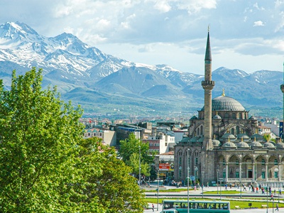
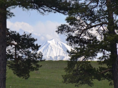
| Mount Ararat | Ağrı / Iğdır | 39.7020, 44.2980 | 5,137 |
| Süphan Dağı | Bitlis / Ağrı | 38.9310, 42.8310 | 4,058 |
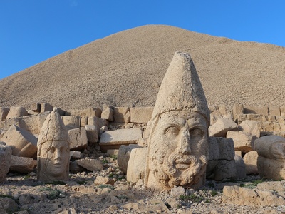
| Nemrut Dağı | Bitlis | 38.6500, 42.2300 | 2,948 |
| Tendürek Dağı | Ağrı / Van | 39.3620, 43.8740 | 3,512 |
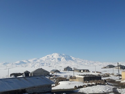
| Erciyes Dağı | Kayseri | 38.5280, 35.4850 | 3,917 |
| Hasan Dağı | Aksaray / Niğde | 38.1300, 34.1670 | 3,268 |
| Karaca Dağ | Şanlıurfa / Diyarbakır | 37.6670, 39.8330 | 1,957 |
| Göllü Dağ | Niğde | 38.2560, 34.5650 | 2,143 |
| Acıgöl-Nevşehir | Nevşehir | 38.5700, 34.6200 | 1,689 |
| Kula Volcanic Field | Manisa | 38.5830, 28.5170 | 750 |
| Karacadağ (Central) | Konya | 37.3000, 32.8000 | 1,724 |
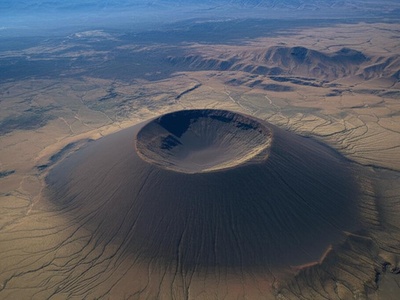
| Meke Dağı | Konya | 37.6890, 33.6420 | 1,301 |
| Melendiz Dağı | Niğde / Aksaray | 38.2160, 34.3410 | 2,963 |
| Girekol Tepe | Van | 39.1670, 43.3330 | 2,836 |
| Kösedağ | Sivas / Erzincan | 40.1060, 38.0060 | 3,340 |
Images and Descriptions
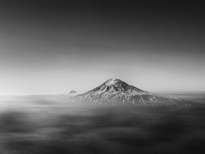
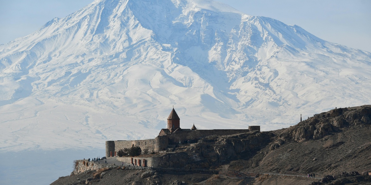
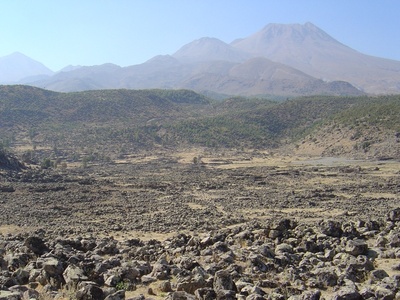
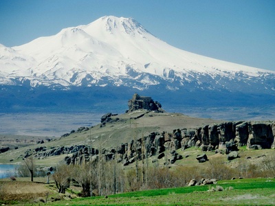
Mount Ararat
A massive, dormant stratovolcano and Turkey’s highest peak, revered as the biblical resting place of Noah’s Ark. Its last confirmed eruption was a phreatic event in 1840. Its two peaks, Greater and Lesser Ararat, are capped by a permanent ice field.
Süphan Dağı
A dormant stratovolcano and the second-highest volcano in Turkey, located just north of Lake Van. While its last eruption date is unknown, it occurred during the Holocene epoch. The summit holds a small glacier and a lava dome-filled crater.
Nemrut Dağı
A dormant polygenetic volcano famous for its vast summit caldera, which contains one of the world’s largest caldera lakes. Its most recent eruption was a small flank event in 1692, making it one of Turkey’s most recently active and potentially hazardous volcanoes.
Tendürek Dağı
An active shield volcano known for its paired summit cones and extensive basaltic lava flows. Its last eruption was a gas and ash emission in 1855. It is one of the few volcanoes in Turkey to have erupted in the last 200 years.
Erciyes Dağı
A prominent, dormant stratovolcano that towers over the city of Kayseri. Its last eruption is estimated to have been around 253 BCE. Today, its heavily eroded slopes are home to one of Turkey’s most popular ski resorts.
Hasan Dağı
A dormant twin-peaked stratovolcano in the Cappadocia region. Its last major eruption was around 6,600 BCE. Obsidian from Hasan Dağı was famously traded by Neolithic people and used to create tools found at the ancient settlement of Çatalhöyük.
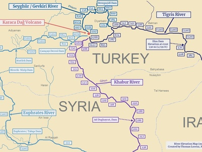
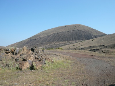
Karaca Dağ
A massive, low-angle shield volcano covering over 2,000 square kilometers in southeastern Turkey. This dormant volcano, with an unknown last eruption date, is considered a potential origin site for the domestication of einkorn wheat due to its unique basaltic soils.
Göllü Dağ
A dormant rhyolitic lava dome complex in Central Anatolia. It last erupted around 6,950 BCE and was a critical source of high-quality obsidian for Neolithic communities. The summit features a well-preserved 2-km-wide crater and several smaller cones.
Acıgöl-Nevşehir
A dormant caldera complex within the famous Cappadocia region, known for its fairy chimneys. Its last eruption, a powerful Plinian event, occurred around 2,080 BCE. The caldera floor is dotted with numerous maars, cinder cones, and lava domes.
Kula Volcanic Field
An extensive, dormant volcanic field in western Turkey, known since antiquity as “Katakekaumene” (the burnt lands). It features over 80 cinder cones and fresh-looking lava flows, with its most recent eruption dated to the Holocene.
Karacadağ (Central)
An extinct shield volcano located on the Konya Plain in Central Anatolia, distinct from the larger Karaca Dağ in the southeast. This Quaternary volcano is characterized by its broad, gentle slopes formed by fluid basaltic lava flows from a central fissure system.
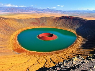
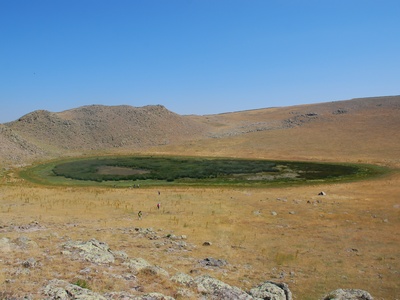
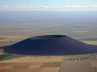
Meke Dağı
A stunning, dormant maar (volcanic crater lake) within the Karapınar Volcanic Field, often called the “evil eye of the world.” Formed during the Holocene, it consists of a water-filled crater with a central red cinder cone, creating a unique and picturesque landmark.
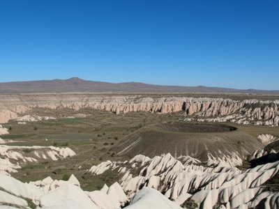
Melendiz Dağı
An extinct and heavily eroded stratovolcano that is part of the Cappadocian volcanic province. Along with Erciyes and Hasan Dağı, its eruptions millions of years ago deposited the thick tuff layers that were later carved into Cappadocia’s famous rock dwellings.
Girekol Tepe
A potentially dormant pyroclastic cone located southeast of Tendürek volcano. Also known as “Koran Dagh,” this Holocene-era volcano has a well-preserved crater. Its activity is linked to the same tectonic fault system as its larger and more active neighbors.
Kösedağ
An extinct stratovolcano located in north-central Anatolia, notable for its prominent and symmetrical cone. Formed during the Miocene to Pliocene eras, it has not been active in recent geological history and is now a significant regional mountain landmark.